Sedimentary History of the Grand Canyon
| ✅ Paper Type: Free Essay | ✅ Subject: Geography |
| ✅ Wordcount: 3847 words | ✅ Published: 08 Feb 2020 |
The Grand Canyon, located in Arizona, is a relatively young canyon according to the geologic time scale as it has formed over the last 6 million years. The canyon was carved by the Colorado River, the history of how the river developed is unknown but widely debated based upon sediments found in different areas where the river flowed. Despite debate over development, the river was fed by meltwater coming from the Rocky Mountains and is 1 mile deep in some places (Karlstrom, Timmons, & Crossey, 2012). The formation of the canyon has exposed an extensive history of rock units that were deposited beginning in the Proterozoic Eon which dates back 2.5 million years. The Grand Canyon was designated a national park in February of 1919 and has since been a popular tourist destination for its breathtaking view of nearly two billion years of geologic history (NPS, 2019).
The majority of the rock units of the Grand Canyon can be seen in the Eastern Grand Canyon (Karlstrom et al., 2012). The rock layers can be subdivided into two categories based on time period of deposition; in the lower half of the grand canyon there are tilted layers that were deposited in the Neoproterozoic Era while the layers above the Great Unconformity were all deposited during the Paleozoic, ranging from the Cambrian Period to the Late Carboniferous Period (Karlstrom et al., 2012).There are eight major formations from the Paleozoic Era, three groups from the Late Precambrian Era, and two formations from the Early Precambrian Era, but three groups and formations from the eight provide an abundance of information regarding the depositional environments, sea level and climate history, as well as a strong fossil record (NPS, 2019).
While the majority of the rock units of the Grand Canyon are sedimentary, the deepest layer of rock is metamorphic, the Vishnu Schist, and immediately above an igneous rock layer, named the Zoroaster Granite, is found. These units are referred to as the Vishnu Basement Rocks and are a record of the formation of the continental crust of North America. The basement rocks of the Grand Canyon show the evolution of this area over time; volcanic island arc formed from 1840 to 1710 Ma and then welded together from 1710 to 1680 Ma creating Laurentia, an early form of the North American continent (Karlstrom et al., 2012). Following the Basement Rocks in an upward succession is an unconformity from Precambrian times and then the deposition of the Supergroup which includes the Unkar Group, the Nankoweap Formation, the Chuar Group and Sixtymile Formation (Ford, Hendricks, & Stevenson,1990). There is a large span of time that is unaccounted for in the rock record which is represented here through the Great Unconformity; it is between the end of the Precambrian Era and the Beginning of deposition of Paleozoic rock layers. The Paleozoic strata consists of exclusively sedimentary rock layers and includes the Tonto Group, Temple Butte Limestone, Redwall Limestone, the Supai Formation, Hermit Shale, Coconino Sandstone, the Toroweap Formation, and the Kaibab Limestone (Beus & Morales, 1990). There
This paper will focus onthe Chuar Group and Sixtymile Formation from the Neoproterozoic Era (1000ma – 750 ma) and the Tonto Group from the Cambrian Period (450 ma -485 ma). The Chuar Group is directly above the Nankoweap Formation and below the Tonto Group; it also is below the Great Unconformity as seen in the figure below. Many different  sources have included Sixtymile Formation in the Chuar Group when discussing the geologic history while others have discussed it as separate from the group. For this paper, Sixtymile formation will be discussed as a rock unit separate from the Chuar Group. The Chuar Group is a part of a larger group known as the Grand Canyon Supergroup which includes The Unkar Group, which is subdivided into five different rock units, the Nankoweap formation, the Chuar Group and Sixtymile formation. The Chuar Group itself is subdivided into two formations, the Kwagunt Formation and the Galeros Formation; both the Kwagunt Formation and the Galeros Formation are further subdivided into seven smaller sections known as memb
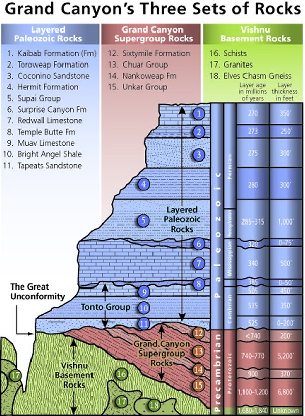 ers. The Kwagunt includes the Walcott, the Awatubi, and the Carbon Butte while the Galeros Formation includes Duppa, Carbon Canyon, Jupiter, and Tanner (Johnston et al., 2010).

Figure 1Stratigraphy of the Grand Canyon. (Mathis & Bowman, 2006)
The rocks in the Chuar Group have been aged to be between 1.09 Ga and 0.74 Ga based on two different aging techniques discussed by Weil, Geissman, and Van der Voo (2003). The upper age bracket was found using the Rubidium-Strontium dating method on the Cardenas Basalts that are below the Chuar Group while the age for the upper section of the group was found using uranium-lead dating of Zircons found in the rock layer (Weil et al., 2003). The discussion of rock units will be in chronological order, beginning with the oldest in Precambrian times up until the Cenozoic Era.
When looking at all layers in the Chuar Group, it is composed of shale, mudstone, limestone, and sandstone (Ford, 1990). Based on the overall composition of the Chuar group before delving into the makeup of each formation and their members, we can infer that the environment that deposited these rock layers is likely marine in some form due to the carbonate limestones, the shales, and the mudstones (Ford, 1990; Weis et al., 2003).
Of the Chuar Group, the Galeros Formation is the oldest, with the oldest member of this group being Tanner which is composed of very coarse dolomite, which is carbonate composed of calcium, magnesium and carbonate, below a layer of shale. Carbonates are commonly formed and deposited on carbonate shelves, tidal flats, and the deep ocean. Ford claimed that the Tanner member’s geology indicated a sediment starved basin based upon the presence of shale and carbonate (1990). Based on the carbonates as well as shale, it is likely that this was a type of marine environment. Jupiter contains both carbonates and shale as well, with a larger concentration of shale, indicating a marine or tidal environment as well. There is also the presence of thin clay heavy beds alternating with thin beds of sandstone and siltstone that have sedimentary structures highly indicative of a marine environment. Many of these thin beds have mud cracks, ripple marks, and salt pseudomorphs, which are crystals that formed when salt water has dried out (Ford 1990). Fossil stromatolites, or stromatolite like features, have been found in the Jupiter layer including both Baicalia-Boxonia and Stratifera- Inzeria; these are ancient mats of cyanobacteria that is no longer around today (Ford, 1990; NPS, 2015). In Ford’s assessment he claimed Jupiter’s shale is representing either a coastal or alluvial plain and based on the many beds with tidal and marine structures and the stromatolite columns throughout, it is more likely that this area was once coastal, not alluvial (1990).
The Carbon Canyon Member of the Chuar Group is alternating layers of shales, limestones, and sandstone (Ford, 1990). The sequences of the sandstone, limestone, and shale are representative of a rising and falling sea level over time. The limestone is made up of dolomitic micrite with chert and quartz, all commonly found in marine environments. In some areas, it is common to find the carbonates merge into calcium rich siltstones. The shales vary in color from a blue-black color to a reddish mudstone with green bands (Ford, 1990; Elston, 1979). The sandstones are not as common in the repeating sequences of shale, limestone, and sandstone, but are made of sub-angular quartz. The presence of this quartz can be indicative of a marine or beach environment as it is relatively weathered and is probably similar in size to the quartz we find on many beaches today. Similar to the member directly below the Carbon Canyon, there are mud cracks in the sandstone and laminations that appear to show some misleading cracks that could be mistaken for worm tracks. In this member of the Galeros Formation, similar to the Jupiter Member, there is evidence of stromatolites being present at this time along with Chuaria which has been defined as both a primitive brachiopod and a subfamily of Amnicolidae, which is part of the mollusk family, in different papers (Ford 1990). Further research classified the Chuaria fossils that were found as acritarches based upon its small size, 2-3mm in diameter, chemical composition, and other characteristics (Ford & Breed, 1973). Along with the sediment being representative of a marine environment, the presence of marine fossils, and sedimentary structures common to marine, tidal, and coastal environments. According to Ford, Carbon Canyon’s alternating limestone and shale could be evidence of a mixed coastal area or a swamp (1990). With the evidence presented, it is most likely that Carbon Canyon was once a mixed coastal area due to the rising and falling sea level that was shown in the Jupiter Member.
Above Carbon Canyon, the Duppa Member is lacking the limestone present in the rest of the group but is made of red mudstones and argillaceous shale; according to Ford this combination of rock layers in the Duppa Member could represent an alluvial fan (1990). Based on sediment alone, it is possible to believe that the past environment may have been alluvial, but when including the fossils found in the layers, structures present in the different layers, and geochemical trends, it is near impossible to argue that the Galeros Formation is not marine in nature (Weil et al., 2003; Porter & Knoll, 2000).
The Kwagunt Formation is the upper part of the Chuar Group and is divided into three members, Carbon Butte, the Awatubi, and the Walcott, with Carbon Butte being the oldest member. While there was sandstone present in the lower half of the Chuar Group, it was in thin sections unlike the base of the Kwagunt Formation. Carbone Butte is the base member of the Kwagunt Formation and overlays the Galeros beginning with a thick layer of red sandstone which is followed by purple shale that has mud cracks and cross bedding present (Ford, 1990). The presence of shale, mud cracks, and stromatolites suggests a marine environment as well.
Directly above Carbon Butte is the Awatubi Member which is marked by a large stromatolite layer that was deposited on top of the Carbon Butte Member. The remainder of the member is predominantly clay shales and mudstones, with the occasional thin layer of siltstone (Ford, 1990; Elston, 1979). Stromatolites are present in Carbon Butte, similarly to all of the rock units below this member. Alongside the Boxonia Koroljuk stromatolites, there is a reappearance of Chuaria circularis, the ancient brachiopods, in the shales of this member (Ford, 1990).
The Walcott Member is the top rock unit in the Kwagunt Formation and is much more diversified in terms of rock types than the previous two layers. The base of this layer is composed of dolomite that is nearly 9 feet thick and has flakes of disturbed algal-laminae (Ford, 1990). Above the massive layer of dolomite are layers of black shales with more Chuaria rich and cherty pisolite beds; pisolite is a sedimentary rock that is made mostly of limestone and is commonly found on shallow sea floor (NPS, 2019; Ford, 2019). As it is stratigraphically above both the Awatubi Member and the Carbon Butte Member, Chuaria was first discovered in the Walcott Member and later found in the Awatubi and Carbon Butte Members (Ford & Breed, 1973). This fossil has been found in many places around the world and had been used to estimate the ages of other rock formations such as the Chapoghlu Shale in Iran and in rock units in Siberia (Ford & Breed, 1973). Another fossil found in this layer is the Melanocryillium which is a vase shaped microfossil with little to no indication of origin and affiliation with other fossils; as of today, it has been reclassified and renamed (Fossil, 1990).
When looking at the Chuar Group in full it can be seen that the area was once a marine environment, ranging from shallow tidal to a deeper marine setting. The succession of rock types, specifically the dolomite to layers of mudstone and limestones, suggests that over the time of deposition sea-level was fluctuating. This idea is supported by the abundance of carbonate layers, the ripples, laminated bedding found on the shale and mudstone, the salt pseudomorphs, and the marine fossils. While alluvial, fluvial, and lacustrine environments have been suggested as the depositional environments of the Chuar Group, most evidence is best suited to a marine or coastal environment (Porter & Knoll, 2000). The combination of stromatolites and limestone in the same rock unit implies an intertidal environment while the pisolite beds that are indicative of shallow sea floors also indicate subtidal and shallow waters (Ford, 1990; Karlstrom et al., 2012). The rock units with fossils including the Chuaria, the Melanocryillium, stromatolites, and algae flakes present in different layers suggests marine impact. Despite debate, most in the geologic community today agree that the depositional environment of the Chuar Group was strictly intertidal or marine, but there is discussion as to the type of marine environment. One idea is that the area was a relatively calm marine embayment with anoxic bottom waters that was connected to the open ocean (Johnston et al., 2010; Porter & Knoll, 2000). The salt pseudomorphs in the Jupiter Member of the Galeros Formation indicated evaporation of salt water as salt crystals had been left behind in the shale and mudstones. The presence of these pseudomorphs indicated that there was once saline water which connect to the idea of a marine embayment connecting to the open ocean.
At first glance, Sixtymile Formation, which is directly above the Chuar Group, is much different compositionally than the formations of the Chuar Group. At the base of the Sixtymile Formation, the rock unit transitions from marine shale to sandstone (Elston, 1979). The remainder of the rock unit is breccia and coarse sandstone with the occasional slump roll (Ford, 1990). There are also rocks from Chuar Group rock units mixed in with the deposition of Sixtymile Formation (Elston, 1979). Slump rolls are masses of unconsolidated materials and rock layers that have moved down a slope. During this time in geologic history, when the Sixtymile formation was being deposited, there was massive uplift and shifting of already deposited materials (Elston, 1979). This uplift was known as the Grand Canyon orogeny and was the end of deposition into the Grand Canyon Supergroup and the precursor to the Great Unconformity. This uplift is what caused the tilted rock layers that were deposited in Precambrian times and also explains the breccia, loosely consolidated material, and coarse sandstones to form (Elston, 1979; Ford 1990). The breccia is from the uplifting breaking the rock units and depositing parts of the older rocks to higher elevations when Sixtymile Formation was forming. Based on the sediments deposited here, assessment of a depositional environment could be difficult. Many have said that the deposits are alluvial in nature but also have evidence of fluvial transport; the alluvial fan is likely due to the debris flow that was occurring due to the tectonic uplift in the earth’s crust.
Above the Sixtymile Formation is the Great Unconformity which marks millions of years missing in the geologic record; geologic records are missing all over the world, not just in the Grand Canyon. The cause of this massive gap is unknown but there is speculation as to what caused it. Some say that this lack of sediment is evidence of a time where a rising sea did not allow for deposition (Middleton & Elliot, 1990). Other sources claim that there was great tectonic activity and uplift globally that may have led to a gap in the record (Weil, Geissman, & Van der Voo, 2003).
The first layer of deposition after the Great Unconformity is the Tapeats Sandstone followed by the Bright Angel Shale, and Muav Limestone; these three layers are known as the Tonto Group because they are not separated by unconformities but instead grade into one another. All formations of the Tonto Group were deposited between 525 ma – 505 ma (Bethault, 2004; NPS, 2019) The Tapeats Sandstone is the first layer of horizontal deposition in the Grand Canyon and is largely made medium and coarse grained, quartz-heavy sandstone while the bottom of the layer is loose pebbles, cobles, and boulders (Berthault, 2004). The sandstone that dominates the middle of the formation is coarse grained and has cross beds that indicate water currents flowing towards the west. The beds likely show that this was a fluvial area at one point despite other indications of marine influence (Berthault, 2004; Middleton & Elliot, 1990). The upper part of the formation closest to the Bright Angel Shale is beds of sands with ripples and above that, finer beds of silt and sand (Berthault, 2004; Middleton & Elliot, 1990). In the upper part of the formation, fossils such as trilobites are found that have been dated to an Early Cambrian age while the middle part of the formation has trilobite fossils dating to the Middle Cambrian giving accurate age estimates for the time of deposition (Middleton & Elliot, 1990).
The Tapeats has been discussed as two separate sections for depositional environments, the first facies referring to the lower part of the formation, is indicative of beaches and intertidal flats due to the bedding showing offshore transport of sediment and scouring structures that likely indicated a rip current of some sort in a marine setting that may have had depths of up to 100 feet (Middleton & Elliot, 1990). The upper section of the Tapeats Sandstone is characterized by fluvial deposits as well as marine deposits; the combination of these two deposits leads geologists to believe that as this section was depositing, there was a fluvial environment that was feeding into a marine environment (Middleton & Elliot, 1990).
The Bright Angel Shale of the Tonto Group has been the least studied rock unit and therefore does not have an in-depth depositional environment analysis. The shale formation has beds of sandy dolomite and argillaceous limestone (Berthault, 2004). From this along with the trilobite fossils found, it can be assumed the Bright Angel Shale was once a deep-water environment that had slow currents due to the lack of bedding present (Berthault, 2004; NPS 2019; Middleton & Elliot, 1990).
The final and youngest member of the Tonto Group is the Muav Limestone. There have been seven members define in the Muav Limestone based upon composition and the fauna present (Middleton & Elliot, 1990). This formation has a wide array of rock units ranging from dolomitic and calcium rich mudstones and packstone to conglomerates separated by beds of siltstone and shale with varying thicknesses in different parts of the canyon (Middleton & Elliot, 1990). There have been different species of trilobite found in the Muav Limestone as well as smaller burrowing organisms. It is assumed that this formation was deposited in a subtidal environment due to the faunal fossils found in the area and the rock units present. A subtidal zone would also accommodate the deeper marine fossils, like trilobites, that are abundantly present (Middleton & Elliot, 1990).
While the Chuar Group may be able to tell a near complete history of the past environments in the area through its sediments, structures present in the different layers, it has also been able to show climate trends, paleomagnetic history, and the tectonic history over time with the help of geochemical trends. Similar to the Chuar Group, the Tonto Group, while smaller in terms of formations and subsequently members, is able to delve deep into the geologic history of the area. The Chuar Group may be the most helpful rock units in determining history, many other layers of the Grand Canyon contain sediment and fossils that can also reconstruct depositional environments. Looking at the fossil conjoined with the predominant rock type in each subsequent unit following the Chuar Group, a general idea of past environment can be determined.
A general overview of fossil assemblages in the Grand Canyon area helps determine possible environments of deposition. The Kaibab Limestone, which is the youngest rock layer of the Grand Canyon, is the most fossil rich. It was deposited between the Late to Mid Triassic Epoch and consists of many different marine fossils. Corals, lacy bryozoans, brachiopods, crinoid stems, horn corals, and sponges have all been found in this rock unit. The presence of multiple well-known marine fossils easily suggests that the Kaibab Limestone was the product of a marine or tidal environment. The Hermit Shale is known for plant fossils in the form of impressions or trace fossils such as seed ferns, horsetails, and small pies (NPS, 2019). These fossils present suggest an arid climate based on the conditions necessary for the plants to thrive. Another set of fossils that is not unique to a certain layer is trilobites. The presence of trilobites indicates a marine environment during the Paleozoic Era. Fossils can provide valuable insights alone with sediment type when assessing past environments.
Based on the two groups, the Chuar and Tonto, it is evident that over the course of the grand canyon’s history, the area was frequently exposed to different forms of coastal, tidal, and marine environments. There is a heavy presence of dolomitic limestone and shale in the area. When rock units began depositing in Paleozoic times, there was an abundance of marine fossils being preserved after the Precambrian increase in living organisms. Overall, the Chuar Group and Tonto Group provided a detailed insight as to the past depositional environments of the Grand Canyon based on sediment type, sedimentary structures, and fossil assemblages, all which indicated a heavily marine influenced environment over time.
References
- Berthault, G. (2004). Sedimentological interpretation of the Tonto Group stratigraphy (Grand Canyon Colorado River)1. Lithology and Mineral Resources, 39(5), 480-484.
- Beus, S.S. & Morales, M. (1990). Grand Canyon Geology. New York, NY; Oxford University Press.
- Elston, D.P. (1979). Late Precambrian Sixtymile Formation and Orogeny at Top of The Grand Canyon Supergroup, Northern Arizona. Geological Survey Professional Paper 1092. United States Government Printing Office, Washington
- Ford, T.D. & Breed, W.J. (1973) The Problematical Precambrian Fossil Chuaria. Paleontology,16(3): 535-550
- Ford, T.D. (1990). Grand Canyon Supergroup: Nankoweap Formation, Chuar Group, and Sixtymile Formation. Grand Canyon Geology (pp. 49-70). New York, NY; Oxford University Press
- Johnston, D.T., Poulton, S.W., Dehler, C., Porter, S., Husson, J., Cenfield, D.E., & Knoll, A.H. (2010). An emerging picture of Neoproterozoic ocean chemistry: Insights from the Chuar Group, Grand Canyon, USA. Earth and Planetary Science Letters, 290: 64-73.
- Karlstrom, K., Timmons, J.M., & Crossey, L. (2012). Introduction to Grand Canyon geology. The Geological Society of America: Special Paper 489, pp.1-6.
- Mathis, A. & Bowman, C. (2006). Telling Time at Grand Canyon National Park: Grand Canyon National Park. Retrieved from: https://www.nps.gov/articles/age-of-rocks-in-grand-canyon.htm
- Middleton, L.T. & Elliot, D.K. (1990). Tonto Group. Grand Canyon Geology (pp. 83-106). New York, NY; Oxford University Press
- NPS. (2015). Grand Canyon National Park: Fossils. Retrieved from https://www.nps.gov/grca/learn/nature/fossils.htm
- NPS. (2019). Grand Canyon National Park: Geologic Formations. Retrieved from https://www.nps.gov/grca/learn/nature/geologicformations.htm
- Porter, S.M. & Knoll, A.H. (2000). Testate amoebae in the Neoproterozoic Era: evidence from vase-shaped microfossils in the Chuar Group, Grand Canyon. Paleobiology, 26(3), pp. 360-385
- Weil, A.B., Geissman, J.W., & Van der Voo, R. (2003). Paleomagnetism of the Neoproterozoic Chuar Group, Grand Canyon Supergroup, Arizona: implications for Laurentia’s Neoproterozoic APWP and Rodinia break-up. Precambrian Research, 129(2004), pp. 71-92
Cite This Work
To export a reference to this article please select a referencing stye below:
Related Services
View all


DMCA / Removal Request
If you are the original writer of this essay and no longer wish to have your work published on UKEssays.com then please click the following link to email our support team:
Request essay removal