Proposal for Wind Farm Using Windpro Software
| ✅ Paper Type: Free Essay | ✅ Subject: Engineering |
| ✅ Wordcount: 3371 words | ✅ Published: 30 Aug 2017 |
INTRODUCTION:
The world is experiencing an extraordinary boom of renewable energy as never before in the history. The main reason for this is mainly global warming, which is reflected by the greenhouse effect, resulting in a large part in rising temperatures.
Two figures to visualize this boom; According to IEA (International Energy Agency) two wind turbines are installed every hour in China and every day and according to the same source 500,000 photovoltaic panels are installed throughout the world.
So, what makes renewable energies optimistic?
The answer is that there are two very powerful motor behind that:
The first is the human genius thanks to which we have made giant steps in the renewable energy to the point that they become almost as profitable as the sources of classic energy.
For example, according to IRENA (International Renewable Energy Agency) the cost of photovoltaics decreases by 70% between 2010 and 2015 same thing with regard to wind energy with a decrease of 40%
When the second engine is the political will with mainly the signing of the decree like the COP, the public subsidy, the different facilities offered, etc.
PURPOSE:
The main purpose of this report this to make a technical-economic design of a wind farm in a choosing place using wind pro software to attract potential investors.
PROBLEM:
The criteria for choosing a wind power plant depend on the size, power and number of units. The efficiency of a wind turbine depends on the regularity and the power of the wind. The most interesting sites are generally located by the sea or to the tops of hills and clear mountains. It can also be a solution in countries where the interconnection lines will not succeed because of the low population density even if the winds are not optimum.
Having the freedom to choose a site, and coming from Algeria my assessment will be focused in one of the most favourable area to install a wind farm this country, the choice of the size and the number of the turbines will be according to the meteorological and natural conditions of the region and they will be discussed later on.
SCOPE :
Mainly focused towards fossil fuel energy, the renewable energy sector still poorly exploited in Algeria or at least not at all, the assessments of wind and solar sources are not deeply studied, for the moment the installations available are mostly orientated on experimental basis, few amount for investment and means of research are the principal reason for that despite of the big potential available, specially on solar power where 84% of the country is covert by the Sahara.
Until nowadays 98% of the electrical production in Algeria come from gas, the lasts years increase evolutions in power demand, followed by the falling oil prices have caused a significant budget deficit since the state subsidizes in full the gas destined for the production of electricity, up to 5.5 billion $ in 2014 according to Sonatrach (the Algerian energy company) with an increase of 10% of the energy consumption each year.
Following that and in view of the circumstances in 2015 the Algerian state has declared a national development program for renewable energy with the target to create 22000 MW of power by 2030, 4500 MW will be realized from here to 2020 according to the CREG (commission for the regulation of electricity and gas).
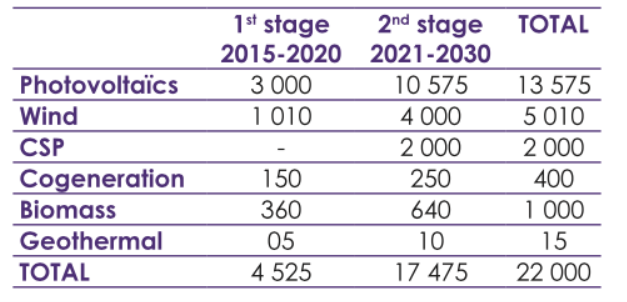
The renewable energy development programme in MW
(source www.creg.gov.dz)
I. Wind assessment:
1.literature assessment:
Several studies about the wind resources in Algeria has been done, and a general wind map was so created with a data measured from a distance of 10m above the ground level, the main methods used were mainly numerical simulations, and extrapolations with the help of meteorological data and several measuring points;
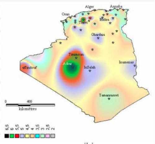 In 2000 a study from Dr N. Kasbadji Merzouk aiming to the creation of a wind chart in Algeria has been published and the results of the annual mean wind speed was illustrated in a map:
In this case of study, 10 years’ wind speed data from 26 stations has been used, and additional data from The National Office of Meteorology in Algeria has been included in order to refine the extrapolation results,
Further calculation that take the 10 m above the ground results to 25m by interpolation had shown the map below :
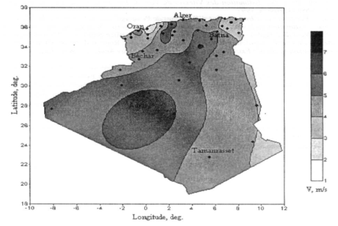
Lasts research in 2013 that took new meteorological data and much more measurement points compared by the one above has been done by Dr. Sidi Mohammed Boudia show results as follows:
Thru those studies we can tell clearly that the main wind speed is concentrated in the south west of the country and specially in the region of Adrar (about 1500km south west of the capital Algiers) where we can see a mean speed of up to 6.5 m/s at 10 m above the ground and up to 7m/s at 25m height, those results are still acceptable for a large onshore project in the way where they push us to know what about the wind speed in up to 100m.
In 2013, an open access data platform has been launched by the international renewable energy agency (IRENA) called the global atlas for Renewable energy, this project is the result of international collaboration from several research institutes like DTU wind energy, private companies and governments, the aim was to bring an easy and a simple way for accessing data and analysis for renewable energy assessment.
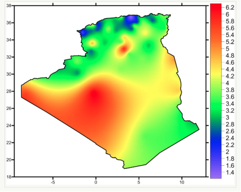
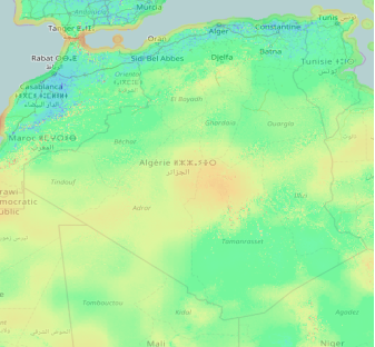 Using this platform, we can find some data that goes up to 200m, we can see the results as below:
(a)
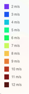
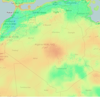
These maps show successively the wind speed in the country at 50m, 100m, 200m. from here and even if the results are not the most accurate, we can see that the real potential of the wind energy in Algeria is becoming more interesting.
2. WindPro assessment :
Having a preliminary knowledge about the wind speed in the country and using the results found on the different research and studies, our assessment using windpro will be focused in the windiest area, namely the Area of Adrar.
The characteristics of the terrain strongly influence the wind flow and thus play an important role in the geographical extrapolation of the wind regime. The WindPRO software and the WAsP flow model are used for this study. WAsP requires a terrain definition through the following input data: elevation, roughness and other obstacles to wind flow
- Site description:
Fatiha Ben Miloud and AL, who have moved to the region to identify some sites in which the wind farm can be installed, claimed that a site has been particularly predominant for its proximity to the electrical substations of Sonelgaz (national society of electricity and gas)
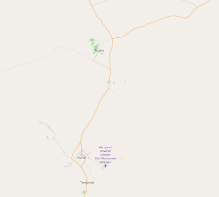
This site is located about 73 km north of the town of Adrar. with an altitude of about 260 m. The available area is large,the topography is flat and the roughness of the ground is weak. Apart from the substation and the electric poles, there are no obstacles in the vicinity of this site.
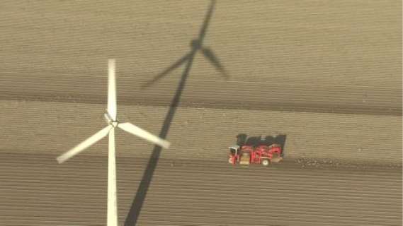
The pictures taken by Fatiha Ben Miloud below show the morphology of the terrain near the Sonelgaz substation.
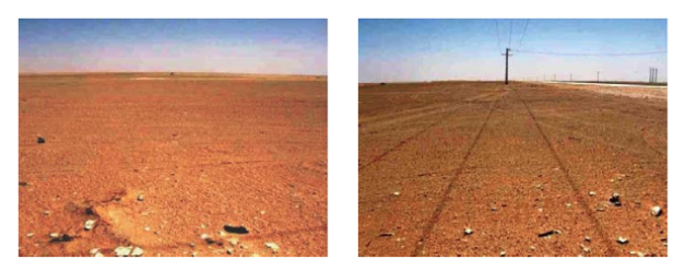
North side West side
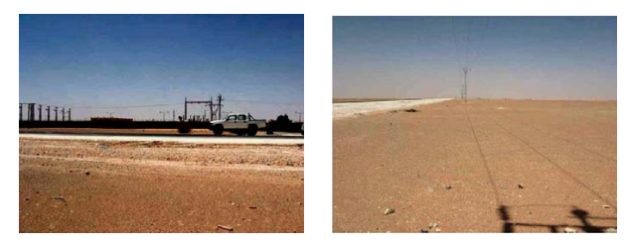
East side South side
Additionally the site is ideal for transport where it is near the road axis Adrar – Timimoun , but the most advantageous is that this site is located close to a HVV substation which reduces construction costs.
From here we can choose the right location using windpro, which requires an exact spot in the beginning to do further simulation.
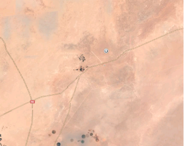
the images above shows the site of the wind farm using Windpro and the Openstreetmap data , we can confirm the research done by Fatiha Ben Miloud about the potential of this area ; the availability of the space is huge , the link to the site is easy ,and there is no perturbation with the surrounding.
BLABLABLABLABLABL
- Wind regime on site:
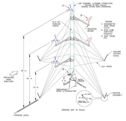
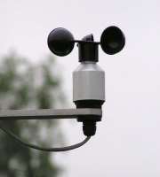
defining the wind regime on a chosen site are usually done using meteorological measure instruments called anemometers, those devices are specially used to do wind assessments like speed and direction. It is highly recommended to make up to 2 years of measurements on the site in the beginning of a project, and the more traditional methods of that is to stand a mast. Being the most economical solution compares to Sodar and Lidar which can be very expensive despite de accuracy, the mast can be set up to the desired height of measurement and can carries several instruments for temperature measurement and mainly anemometers.
Cups anemometers the most commonly used, figures below can show some designs of those devices, the operating principle is simple; the torque generating from the turning cups under the effect of win, will be transformed in to electrical signal, this last will be calibrated and transformed in to wind speed output.
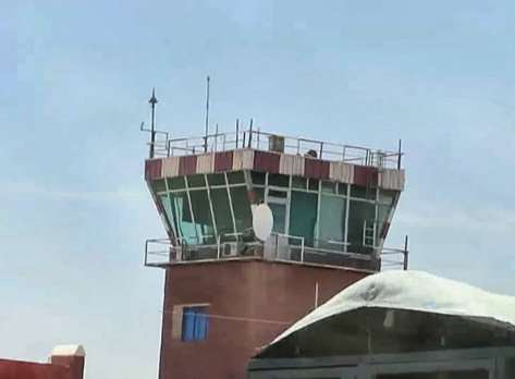
In this case of study. Meteorological data on windpro were given from METAR (METeorological Aerodrome Report) in the closest local aerodrome of Adrar and being designed for only national flight this aerodrome is small and not a very active one, the measurements are taken every 180 minutes from a height of 10m,


the table below summaries the monitoring of the wind in the area :
|
Meteo data |
Adrar_TOUAT_SYNOP_60-620_N27.880_W00.280 |
|
Type de station |
METAR/SYNOP |
|
System |
Cup anemometer |
|
Places of observation |
Control TOWER ( TWR) |
|
height |
10m |
|
Observation |
Every 180 minuts |
|
Intervalle used |
01/01/2007 to 13/04/2016 |
Even if the specification model of the anemometer was not found in the different documentations, the picture below shows clearly the usage of a cup anemometer in the control tower of the aerodrome.
We can also notice and for a software reason that the interval of the measurement stops at 13/04/2016 even if the interval wanted was for 10 years.

The data results from the Metar station are listed in the table below:
|
Height |
M |
10 |
|
Weibull mean speed |
m/s |
5.9 |
|
Weibull A |
m/S |
6.7 |
|
Weibull K |
– |
2.01 |
|
Main wind direction |
– |
NNE, ENE |
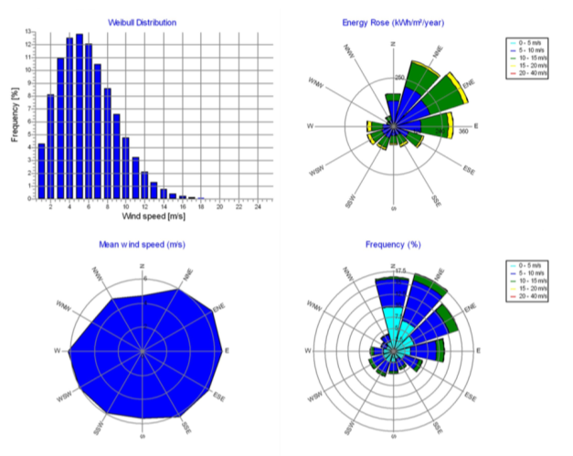
We normally describe the wind variations at a given site using a Weibull distribution like the one
The shape of the curve is determined by a so-called shape parameter equal to 1.750.
This graph is a probability distribution (frequency distribution). The probability that the wind blows at any speed (including zero) is necessarily equal to 100%, the area below the curve will always be exactly 1.
The statistical distribution of wind speeds varies from place to place as it depends on the local climatic conditions, the landscape and its surface. The Weibull distribution therefore tends to vary, both in form and in average value.
These results show the concordance between the research carried out in the literature assessment done in the first part and the data analysis from windpro , where we can see clearly that the dominant wind direction is NNE and ENE , with a mean speed of 5.9m/s
Additionally, to this, the WAsP methodology is used to extrapolate selected wind statistics up to 50 m and later on up to the hub height and up to the location of each wind turbine. The purpose of that is to see the real potential of the wind at a more height altitudes.
Roughness and elevation are the two crucial factors to do wind measurement, this step is crucial when using windpro and more precisely for WAsP.
- Elevation:
The wind regime can be strongly influenced by elevation differences. The terrain elevation is modeled within a radius of 5 km and is based on the NASA’s Radar Topography Mission SRTM data. The contours are then generated with an altitude difference of 10 m between two successive curves.
- Roughness:
The roughness is a key parameter of the equation that models the vertical wind profile Any change in roughness causes a change in the vertical wind profile. The impact at the measuring or hub height can vary greatly as a function of the distance from the change in roughness and atmospheric conditions.
Mettre 50 METRE
II.WIND FARM :
- Wind turbines:
Whatever in size, power or efficiency, the choice of the wind turbine depends on several parameters; The nature of the terrain where it will be sitting, the wind resources in the area and the noise level are some of the main criteria and specially for a wind farm development. but further that, the availability and reliability of the models needed in addition of the spare parts are very important factor that decide if yes or not the turbine is taken into consideration. And finally, the availability of warranty, and proximity of operation and maintenance teams is also more than desirable.
Being heavily integrated in Algeria and specially in the energy field, the choice of the US manufacturer GE (General Electric) was made in a strategic point of view in the way where possessing a very large infrastructure, plus an infallible experience in the country, GE can without a big difficulty manufactured the wind turbines in Algeria, which can minimize the costs and facilitate the transport as well as the installation
On this case of study, two different type wind turbines and 16 in total had been choosen:
Model N°1:
|
Model reference: |
GE WIND – GE 2.5-120-2,500 |
|
number |
8 |
|
Hub heights: |
98.3 m |
|
Rotor diameter: |
120 m |
|
Power rated: |
2500 KW |
|
Frequency: |
50 Hz |
|
Noise: |
106 dBA |
|
Class : |
IEC IIIs |
|
Commissioning : |
2014 |
|
Technology: |
Model based controls & Cold weather extreme |
*GE claimed that this model has the world’s most efficient high output wind turbine and has a competitive power value at low wind speed with 98% of reliability from its global fleet.
Model N°2:
|
Model reference: |
GE WIND – GE 1.7-100-1,700 |
|
Number |
8 |
|
Hub heights: |
96m |
|
Rotor diameter: |
100 m |
|
Power rated: |
1700 KW |
|
Frequency: |
50 Hz |
|
Noise: |
107 to 105 dBA with low noise trailing edge technology |
|
Class : |
IEC IIIs |
|
Commissioning : |
2013 |
|
Technology: |
Model based controls, low noise trailing edge, vortex generators, weak grid support |
*GE claimed that this model has the best in class capacity factor with high energy capture in low wind speed environments.
The specific choice of those two model was mainly done because of their high efficiency in low wind speed specially when our farm site has a wind speed lower than 10m/s.
- Sitting:
the choice of the sitting of the wind turbine depend mainly in the available area in the site, the nature of the terrain, and the wind direction, those characteristics define the number of the turbine as well as the way of the sitting.
In our case, even with the availability of a big, flat and empty area, the sitting of the wind turbines will be in two straight rows with 8 x ‘GE 2.5-120-2,500′ in the front and 8 x’ GE 1.7-100-1,700′, The two rows are facing the wind flow an angle of 127°.
the main reason for this configuration is gain the maximum of power with a smaller area of usage in the way where the more powerful turbines are sitting in front of the less powerful ones, but with a particularity where even if the front turbines will absorb the energy
SEE GUIDENCE SITTING PDF TO CONTINUE
MICROSITTING
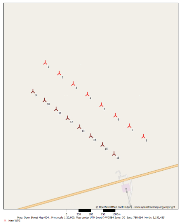
figure : //
The long-term wind regime expected at the representative height at the location of the wind turbines is shown in Table ??? and Figure ???? The mean wind speed at hub height at the location of each Wind turbine is included in Annex E.
|
Location |
E 1,377,483 N 3,181,536 |
||
|
WT model |
GE 2.5-120-2,500 |
GE 1.7-100-1,700 |
|
|
Height |
m |
98.3 |
96m |
|
Weibull mean speed |
m/s |
9.0 |
8.9 |
|
Weibull A |
m/s |
10 |
10.08 |
|
Weibull K |
– |
2.521 |
8.9 |
|
Main wind direction |
– |
NNE, ENE |
NNE, ENE |
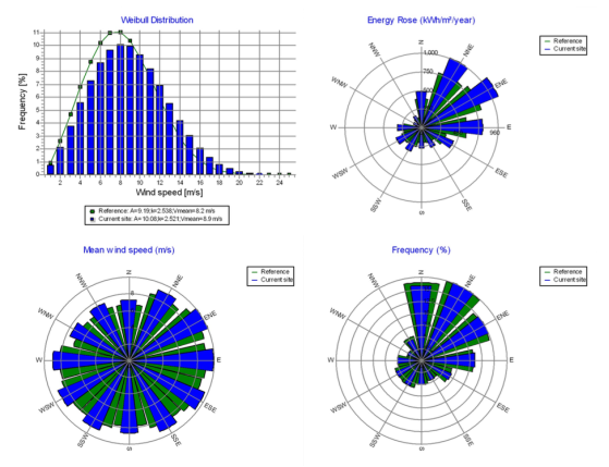
figure : ge 2500
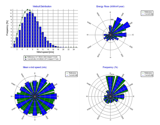
Figure GE 1,7
- Noise:
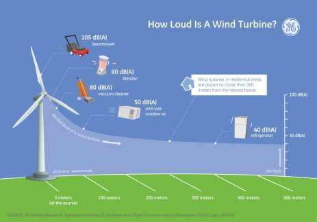
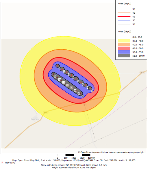
The noise caused by wind turbines and specially in by a wind farm is an important element of the acceptance, or refusal, of these machines by neighboring populations where it can be a source of annoyance and perturbations. It should therefore be assessed, with special care, during public inquiries; And then checked, after start-up of the machines, by measurements in the field.
METTRE LE COMPOSANT QUI FAIT LE BRUITThanks to Windpro, we can perform noise calculations for all the farm. In order to do that, we indicated to the software the average wind speed at this point, but also the height at which we wanted our measurements (the hub), with the help of de wind turbine technical characteristic from the manufacturer.
we were able to obtain the results (ANNEXE) in the form of a map in figure ????
It is then found that at the foot of the wind turbine, there is between 50 and 100 decibels of noise, which corresponds to the noise of a washing machine. But when one moves away from it, the noise falls below 35 decibels, which simply corresponds to the noises normally heard in fields or in a forest.
It can be concluded that, choosing this clear empty field was a very good idea, even with the existence of a small inhabitant village at 3km nearby, the farm will not be hampered by the noise of wind turbines. This is why we would have the right to install the wind turbines.
Having not found the legislation for the distances from the residential premises in Algeria. Distances from some European countries can be given for example. in France, it is not allowed to install a wind turbine within 500m of a dwelling, Denmark and Sweden, the limit is 300m.
- Shadow:
As introduced on the ZVI section. The rotation of the blades causes a periodic interruption of the sunlight (stroboscopic effect) which may possibly be unpleasant. This phenomenon can easily be anticipated. It is highlighted when the sun is low and when the sky is clear of any cloud. The periods of this phenomenon are generally very short and can be seen only near wind turbines.
Using windpro, assumptions for shadow calculations are set up as following:
-Calculate only when more than 20 % of sun is covered by the blade
-Minimum sun height over horizon for influence 3 °
-Day step for calculation

1 days
-Time step for calculation 
1 minutes
The calculated times are “worst case” given by the following assumptions:
-The sun is shining all the day, from sunrise to sunset
-The rotor plane is always perpendicular to the line from the WTG to the sun
-The WTG is always operating
A ZVI (Zones of Visual Influence) calculation is performed before flicker calculation so non-visible WTG do not contribute to calculated flicker values. A WTG will be visible if it is visible from any part of the receiver window.
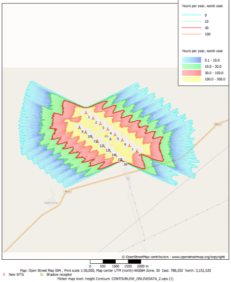
Ones again the we can confirm the good choice of this area, the shadow flickering provided from the wind turbine is out of all king of disruption, where even the near village at 3km down the wind farm won’t be exposed by the shadow, the only disadvantage is the flicker on the road nearby where we can see from 10 to 30 hours per year in the worst case but we can conclude that even with that, it will not cause any problems at all.
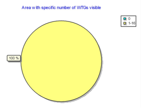
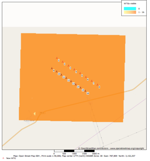
- ZVI:
The installation of wind turbines modifies the landscape. Given their large size, they mark space and are part of a logic of good landscape integration. Wind turbines need to be placed in sites exposed to the wind. The degree of visibility is influenced by factors such as the type of landscape, the number and design of wind turbines, the way they are arranged on the farm, their color and the number of blades.
Other aspect of the visual impact that will be discuss in the next section is the shadow flickering;
During rotation, the blades must cast shadows intermittently, resulting in a flicker or blinking effect on the surrounding area. This effect can cause problems for the population close to the wind farms. Its intensity depends on the rotor speed and direction, the number of hours of sunshine and the geographical location of the installation.
Assumptions done using WindPro for ZVI calculation are as follow:
-Center for calculation: UTM (north)-WGS84 Zone: 30 East: 787,969 North: 3,152,257
-Width of calculation area: 5,118 m
-Height of calculation area: 4,893 m
-Calculation step
: 25 m
-Eye height
:1.5 m
-Calculation area: 2,504 ha
-Highest relevant visible part of a WTG: Hub height + 1â„2 rotor diameter
-Obstacles used in calculation: 0
-No area objects used in calculation
-New WTGs used in calculation: 16
The results of this show that all the 16-wind turbines are visible from the hole calculation area of approximatively 2,500 ha, we can admit that this is one of the biggest disadvantage for having a flat area and specially where it can be visible for the near village situated at 3km down the wind farm , but …… IL FAUT VOIR LA LIMITE
Cite This Work
To export a reference to this article please select a referencing stye below:
Related Services
View all


DMCA / Removal Request
If you are the original writer of this essay and no longer wish to have your work published on UKEssays.com then please click the following link to email our support team:
Request essay removal