Exploring Prospectivity on the Flanks of the Troll Field
Info: 9502 words (38 pages) Dissertation
Published: 9th Dec 2019
Chapter 1 – Introduction
1.1 – Introduction and geographical location
Troll is a super-giant Jurassic field. It is the largest field in the North Sea in oil equivalent terms and the second largest field in Europe after Groningen, accounting for approximately 40% of the Norwegian gas reserves. It was successfully discovered and appraised by Shell and Norsk Hydro (now Statoil) in the late 70’s and early 80’s. On the northern flanks, Mobil and Norsk Hydro discovered the Fram field during a second successful exploration phase in the 90’s. However, success on the western and eastern flanks of the giant field has been limited. During the last 30 years 10 dry wells have been drilled on the flanks of Troll.
A general perception (e.g. Goldsmith 2000 & Horstad et al 1997) is that more hydrocarbons than what have yet been discovered may have migrated into and through the Troll field. According to Goldsmith (2000) the field is filled to spill-point and has a tilted oil-water contact, implying active migration. So where did all the oil go? Perhaps Troll is a unique example of a field that is apparently full to spill, but not spilling?
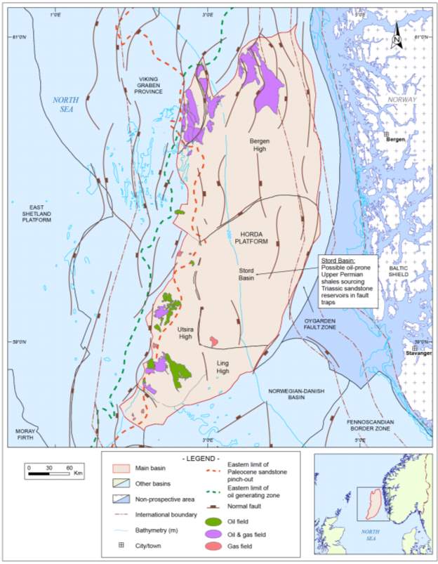
The study area is located within the Bergen High, a sub-basin of the Horda platform. It is located entirely offshore the southwest coast of southern Norway in water depths ranging from 100 m to 200 m. It is a mature and highly productive hydrocarbon area in which Troll and Oseberg are the main fields. The main plays in this area are considered to be Sognefjord, Heather and Fensfjord sandstones of Late to Middle Jurassic age. The basin is roughly diamond shaped with a northeast-southwest orientated axis. The platform is west and southwest of the Viking Graben Province and north of the Norwegian-Danish Basin. Its eastern boundary is the Oygarden Fault Zone. The basin location is shown in Figure 1.1.1.
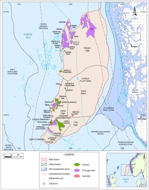
Figure 1.1.1 – Basin location map including sub-basinal areas. (Modified after IHS Markit 2016)
1.2 – Geological setting
According to IHS Markit (IHS Markit, Basin Monitor, 2017) the Horda Platform can be divided into five sub-basinal areas, the Oseberg Fault Block, Bergen High, Stord Basin, Utsira High and the Ling High. The platform is a broad stable area underlain by a high velocity lower crustal body at a depth of some 8.1 to 8.4 km. The northern part of the Horda Platform and the Stord Basin to the south comprise a north-south trending rift zone of Late Permian to Early Triassic age. This area was a “proto” Viking Graben feature with north-south trending, east dipping half grabens. This area contained over 2 km of syn-rift sediments of Permo-Triassic age. The overlying Jurassic shows comparatively minor faulting. Often the faults have been reactivated and are of Triassic age. The boundary between the Horda Platform and the North Viking Graben is characterized by northnortheast – southsouthwest trending, westward throwing faults of Middle to Late Jurassic age.
- The Oseberg Fault Block is a north-south oriented, gently easterly tilted feature which overlaps the transition between the eastern flank of the subsiding Viking Graben and the western edge of the more stable (main) Horda Platform.
- The Bergen High is a north-south trending feature defined by the north-south trending faults of the Oygarden Fault Zone to the east and the north-south trending Oseberg Fault Block to the northwest. The southern part of the Bergen High has a number Permo-Triassic faults orientated north-south, while the northern area is defined by a group of middle to late Jurassic normal faults which dip to the west.
- The Stord Basin is a northeast-southwest trending graben its structural features defined by the northeast-southwest trending faults of the Oygarden Fault Zone to the east and the north-south trending fault system marking the eastern edge of the Utsira High to the west. The Jurassic and Lower Cretaceous succession thickens into the Stord Basin but it is unlikely that any potential source rocks will have been sufficiently deeply buried to generate significant quantities of hydrocarbons.
- The Utsira High is a long established north-south trending broad feature consisting of granites and schists of Late Ordovician age overlain by relatively thin Triassic sediments. The Jurassic and Early Cretaceous age sediments are thin or absent on the crest of this feature.
- The Ling High is the southern extension of the Utsira High. Its western boundary with the Gudrun Terrace (Viking Graben) marks the easterly limit of both the Viking Graben and Zechstein halotectonics. Its southern boundary is with the Ling depression of the Norwegian-Danish Basin.
1.3 – Aims and Thesis Outline
This thesis will focus on exploring the remaining prospectivity on the flanks of the Troll field, a super-giant field filled to spill point suggesting active migration. Work will focus on mapping the migration routes into and out of the Troll field. The mapped migration routes will then be used to map potential prospects on the flanks of the field.
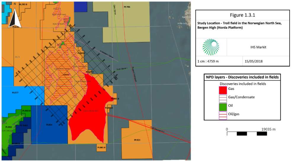
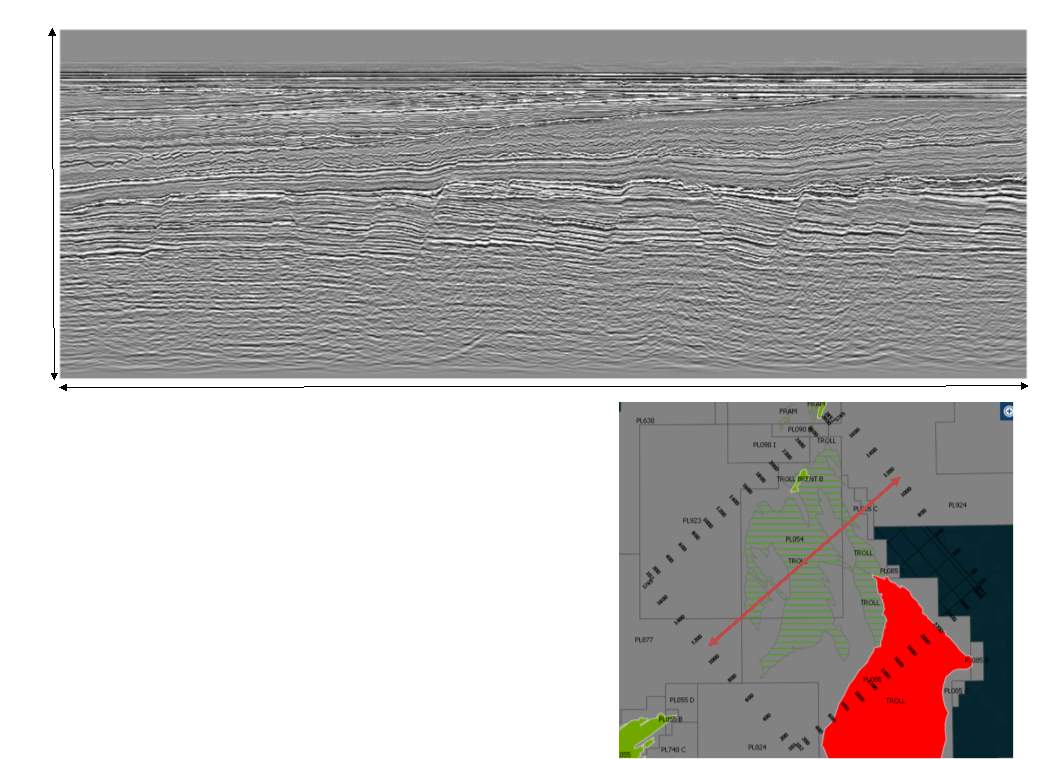
The project area is a 3D cube shot by Norsk-Hydro (now Statoil) in 2003 covering an area of around 1,200 sq.km including the Troll field (Figure 1.3.1).
2.1 Regional Geology of the Horda Platform
2.1.1 Geological Setting
The Horda Platform, on the eastern margin of the North Viking Graben, is underlain by gneiss of metamorphic and igneous origin. The granites were emplaced during the Caledonian Orogeny and are of Late Ordovician age. During the Permian to Early Triassic a north-south trending “proto” North Viking Graben extended across the Horda Platform. This was controlled by en-echelon westerly throwing faults of the Oygarden Fault Zone and the extension of the easterly throwing faults that bounded the Utsira High. Major thicknesses of sediment accumulated in the resulting half grabens formed at this time. These sediments include Rotliegendes Group eolian sandstones and Zechstein Group oil-prone shales and carbonates as well as Lower Triassic alluvial facies of the Early Syn-rift Unit.
The overlying Early Thermal Sag Unit is of Middle Triassic to Bathonian age and comprises seven major clastic wedges, which repeatedly and progressively built out from, and retreated back to the basin margins. Three Triassic alluvial fan sandstone wedges comprise the Lomvi Formation, Upper Lunde Formation and Statfjord Formation. The overlying Lower Jurassic clastic wedges are coastal plain to shoreline sandstones of Johanson and Cook Formation sandstones. The amalgamated fan deltas of the Oseberg Formation sandstones indicate maximum regression. The overlying Brent Group delta comprises the shallow marine delta front sandstones of the Etive Formation overlain by the upper delta complex fluvial sandstones, coals and shales of the Ness Formation. The retreat of the delta is marked by the upper part of the Ness Formation and the transgressive marine sandstones of the Tarbert Formation.
The Horda Platform received a steady supply of clastic sediments during the Jurassic period. This period of uninterrupted deposition has left a fairly complete stratigraphic record of cyclical shore line transgression and regression (Stewart et al. 1995). In the late Middle Jurassic and Late Jurassic, three periods of rifting resulted in the subsidence of the Viking Graben with rather more subtle effects on the tilted fault blocks of the Horda Platform. The main extensional periods were the Middle Callovian to Early Oxfordian, Middle Oxfordian to Kimmeridgian and Early to Middle Volgian. Movement of the fault blocks of the Troll Field during these periods controlled the sedimentation and facies of the Fensfjord Formation and Sognefjord Formation rift marginal sandstone wedges, which are the main reservoirs of the Troll Field. The deposition of the increasingly organic “hot” transgressive shales of the Draupne Formation marks the end of block faulting and the start of thermal subsidence.
The Main Thermal Sag Unit extends from the Berriasian to the Present. Increased thermal subsidence led to the deposition of argillaceous sediments of the Cromer Knoll and Shetland Groups across the Horda Platform area. Both groups are generally thin and locally absent on the adjacent Utsira High. During the Paleocene, the East Shetland Platform was tilted to the west and the Horda Platform to the east. Erosion of the East Shetland Platform led to the deposition of major turbidite fans across the Viking Graben. The distal margin of these extends onto the Utsira High. At the beginning of the Eocene, submarine fan sandstones were deposited across the marine shelf on the Bergen High, while on the Utsira High in the Late Eocene sandstones were deposited. These sandstones of the Grid Formation were laid down in an open marine environment during a regressive period. Middle Miocene uplift of the Norwegian coastal area resulted in the Middle Miocene unconformity, which is locally overlain by thick marine shelf sandstones of the Utsira Formation, which is further overlain by the mudstones of the Nordland Group.
2.2 Stratigraphy and Structure
2.2.1 Basement
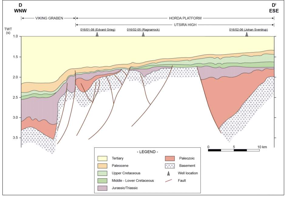
Much of the Horda Platform is underlain by gneiss of metamorphic and igneous origin. The granites were emplaced during the Caledonian Orogeny and are of Upper Ordovician age (Frost et al. 1981). However, only several of the wells drilled in the Horda Platform have ever penetrated the basement. Where encountered it has typically been found to comprise of fractured granite and gneiss (Hospers & Ediriweera, 1991). Recently these fractured basement rocks have been proven to contain movable hydrocarbons, most notably at the Edvard Grieg field where oil was proven in 2007. Basement reservoirs are rare on the Norwegian Continental Shelf (NCS) and work to understand this new exciting play type is ongoing at a number of discoveries in the area.
2.2.2 Permian / Triassic
During the Permian to Early Triassic a north-south trending “proto” North Viking Graben extended across the Horda Platform. This was controlled by en-echelon westerly throwing faults of the Oygarden Fault Zone and the extension of the easterly throwing faults that bounded the Utsira High. Major thicknesses of sediment accumulated in the resulting half grabens formed at this time. These sediments include Rotliegendes Group eolian sandstones and Zechstein Group oil-prone shales and carbonates. An Upper Permian (Zechstein) carbonate reservoir has been reported at the Johan Sverdrup oil (Insert REF).
Continued riftng during this period resulted in the repeated build out from, and retreat back to the basin margins of sediment wedges from Norwegian and East Shetland hinterland. As a result Lower Triassic alluvial facies are widespread. According to Goldsmith et al. (2003) approximately 5% of the total hydrocarbon reserves found in the Horda Platform are contained within Triassic rocks. The strata are typically non-fossiliferous continental red beds (Vollset & Dore, 1984). Three Triassic alluvial fan sandstone wedges comprise the Lomvi Formation, Upper Lunde Formation and Statfjord Formation. The sandstones are typically massive fine- to coarse-grained transitional glauconitic sandstones of fluvial to deltaic origin, which are between 150 and 200 m thick with average porosities of 24% and permeabilities of between 500 and 2,000 mD. According to Raum (1998), fibrous illite is a problem in Statfjord Formation sandstones at depths exceeding 3,500 to 4,000 m. This does not apply to the relatively shallow Horda Platform.
2.2.3 Jurassic
2.2.3.1 Dunlin Group
The Dunlin Group is composed of the Drake, Cook, Amundsen, Johansen and Burton Formations. All except the Burton Formation have been identified on the Horda Platform. The Johansen Formation is present beneath the Troll field and elsewhere on the northern area of the Horda Platform. The sandstone represents large westward and northwest prograding deltas; it is sealed by interbedded Amundsen Formation siltstones and shales. The Johansen Formation has yet to be tested for hydrocarbons on the NCS (REF) however, the sandstones appear to be micaceous and are therefore only likely to have limited reservoir potential.
Sandstones of the Cook Formation, Brent Group (Toarcian to Pleinsbachian) are prograding shelf sandstones, which produce in the Oseberg and Oseberg South fields on the Bergen High. Livbjerg & Mjos (1989) described two north-northeast – south-southwest trending sand bodies in the Oseberg area, interpreted as tidal sand ridges. These are present on the footwalls of major faults. Marjanac & Steel (1997) describe the Cook Formation sandstones more regionally as four sandstone tongues each characterized by a lower zone of sharp based, upward coarsening, thinly bedded shoreface siltstones and sandstones and an erosively based upper zone of thin tidal flat and thick deltaic/estuarine sandstones. These upper sandstones are clean, fine- to coarse-grained and massive or cross-stratified. The lower unit shows deep incisions into the underlying Amundsen Formation.
The Amundsen Formation consists of claystones and sandstones (Marjanac, 1995). The formation contains exclusively marine sediments indicative of deposition on a shallow marine shelf (Vollset & Dore, 1984).
The Drake Formation comprises claystones and sandstones (Marjanac, 1995) and is generally considered to have been deposited in a prodelta or delta front environment (Vollset & Dore, 1984).
2.2.3.2 Brent Group
The Middle Jurassic Brent Group was deposited during a period of regression and consists of deltaic lithofacies. The Lower Brent Group comprises two prograding sandstone lobes underlying the main Brent Group Delta, which built out from the Horda Platform towards the primitive Viking Graben (REF). These thinly bedded, medium to very coarse grained sandstones were deposited by gravity flow avalanches and are overlain by massive, very well sorted, medium to coarse grained micaceous sandstones (Grane et al., 1987; Muto & Steel, 1997).
The overlying Brent Group delta comprises the shallow marine delta front sandstones of the Etive Formation overlain by the upper delta complex fluvial sandstones, coals and shales of the Ness Formation. The retreat of the delta is marked by the upper part of the Ness Formation and the transgressive marine sandstones of the Tarbert Formation.
The Etive Formation sandstones are prograding upper shoreface, barrier bar and distributary channel sandstones forming the lower part of the Brent Delta. They consist of massive fine to coarse grained sandstones, which show an average porosity of 24% in the Oseberg complex with average permabilities of 1 to 4 mD and a net to gross ratio of 98%. These sandstones are also reported reservoirs at the Veslefrikk, Osberg South and Osberg East fields.
The Ness Formation marks the end of the advance of the Brent Delta, the upper part and the overlying Tarbert Formation marks its retreat. The Ness Formation consists of fluvial sandstones interbedded with coals and shales. They are also reported as reservoirs in the Oseberg South, Oseberg East and Brage fields. Individual sandstones are very fine to medium grained, 2 to 25 m thick, sharp based and upward fining. They are elongate, laterally restricted bodies sealed by interbedded shales. Good quality sandstones average 26% porosity and 1,700 mD permeability. Micaceous sandstones average 12% porosity and as a consequence are not as prospective. The sandstones are major reservoirs at a number of fields in the basin, especially Oseberg and Veslefrikk.
The Tarbert Formation sandstones consist of one or more coarsening up sequences of micaceous sandstones overlain by fine- to medium-grained pebbly sandstones. They are important reservoirs in both the Oseberg field (up to 43 m thick) and the Veselefrikk field (5 to 8 m thick).
2.2.3.3 Viking Group
The producing reservoirs at the Troll field belong to the Viking Group. The Krossfjord, Fensfjord and Sognefjord formations are the three major sandstone lobes of the Viking Group.
The Krossfjord Formation sandstones are shallow marine sandstones, medium to coarse grained and well sorted. They appear to be largely restricted to the Troll field where they are water wet. Their lateral extent into the adjacent Brage field is uncertain.
The Fensfjord Formation sandstones are shoreface sandstones prograding westwards and supplied with sediment by rivers draining the Norwegian hinterland (Walderhaug et al. 1989). They consist of a series of stacked 3 to 5 m thick coarsening upward units, each passing upward from micaceous siltstones to fine to coarse grained well sorted sandstones.
The Sognefjord Formation has westward prograding shoreface sandstones similar to those of the Fensfjord Formation. They are important reservoirs in the Troll and Brage fields at the northern end of the Horda Platform. In the Troll field, the formation comprises 11 upward coarsening sequences (REF). Each sequence consists of low energy argillaceous and micaceous sediments passing upwards into well-sorted medium to coarse-grained sandstones of shoreface facies containing abundant bioclastic material. Porosities typically range from 23% to 30% in the Troll field.
During the deposition of the Fensfjord and Sognefjord formations, the shorelines advanced basin-wards in the Early to Middle Callovian and Early to Middle Oxfordian. The sediment supply was greater than the basinal subsidence rate, resulting in a stacked upwards-coarsening shoreline lithology. During the Middle Callovian to Early Oxfordian and Late Oxfordian to Kimmeridgian rift phases, the subsidence rate outpaced sediment supply and resulted in the retreat of shorelines.
2.2.4 Cretaceous
Cretaceous sediments were deposited unconformably over Upper Jurassic sediments of the Northern North Sea. The Syn-rift Jurassic sequence and the post-rift Cretaceous sequence is separated by the Base Cretaceous Unconformity (BCU). This unconformity can be widely correlated across almost the entire basin, has a distinct character in seismic reflection data and therefore is easily identifiable and correlated (Kyrkjebo et al. 2004). This unconformity is significant as it marks the end of the last rifting event and the top of the cap rock for all of the Jurassic reservoirs in the area.
Lower Cretaceous sandstones of the Cromer Knoll Group consist mainly of shallow marine mudstones, shales and some sands (Vollset & Dore, 1984). The Upper Cretaceous period was associated with a period of rising sea level, partly due to increased thermal subsidence during this time, and as a consequence the input of clastic material ceased (Hancock & Kauffman, 1979). At this point sedimentation was dominated by coccolith debris and other carbonate grains with sequences often displaying a cyclic pelagic sedimentation pattern termed periodite (d’Heur, 1986). As a consequence Upper Cretaceous sediments of the Shetland Group typically comprise chalky limestones, marls, mudstones and minor interbedded limestones (Surlyk et al. 2003).
2.2.5 Cenozoic
Sediment architecture during the Cenozoic was influenced by vertical movements caused by tectonic activity which can be attributed to the opening of the northeast Atlantic Ocean (faleide et al. 2010).
During the Paleocene, the East Shetland Platform was tilted to the west and the Horda Platform to the east. Erosion of the uplifted East Shetland Platform led to the deposition of major turbidite fans across the Viking Graben. The distal margin of these extend onto the Utsira High. At the beginning of the Eocene, submarine fan sandstones were deposited across the marine shelf on the Bergen High, while on the Utsira High in the Late Eocene sandstones were deposited. These sandstones of the Grid Formation were laid down in an open marine environment during a regressive period. Middle Miocene uplift of the Norwegian coastal area resulted in the Middle Miocene unconformity, which is locally overlain by thick marine shelf sandstones of the Utsira Formation, which is further overlain by the mudstones of the Nordland Group. In its Upper part the sediments are often poorly sorted reworked glacial and partly marine sediments (Faleide et al. 2010).
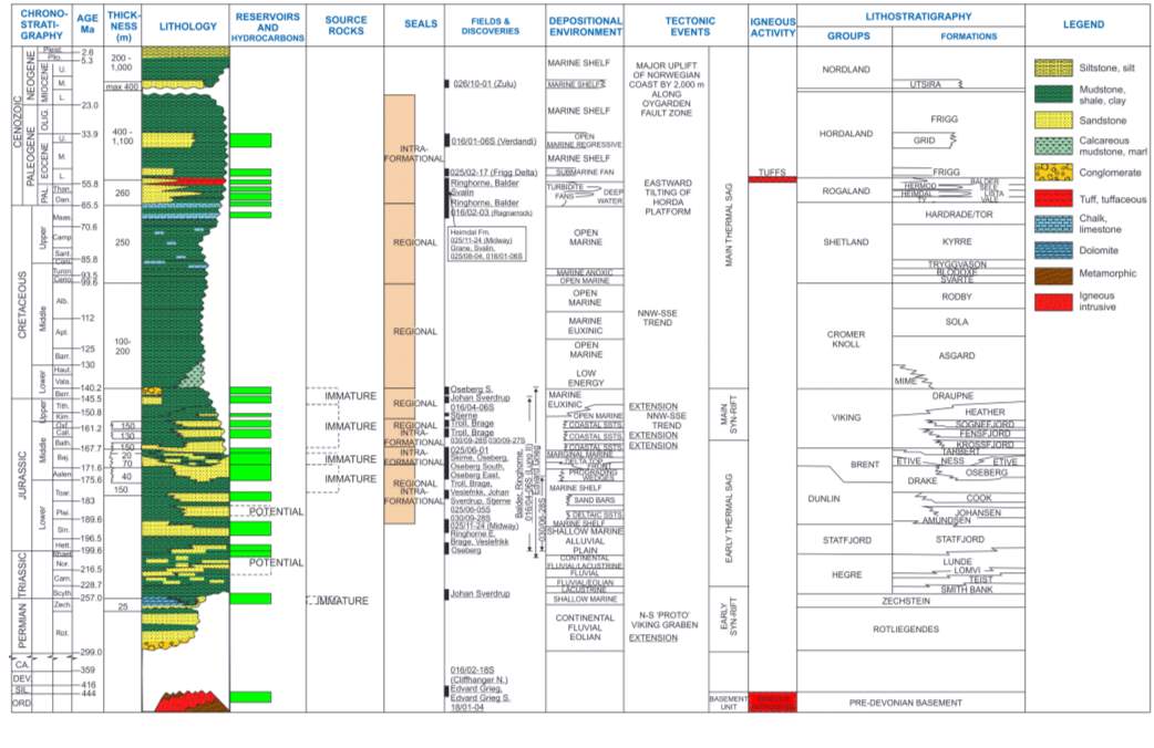 2.2.6 Stratigraphic Chart of the Horda Platform
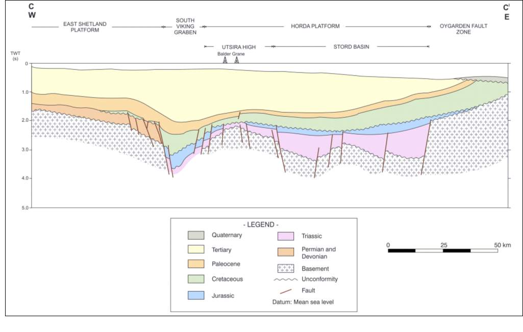
 2.2.7 Structural Framework of the Horda Platform
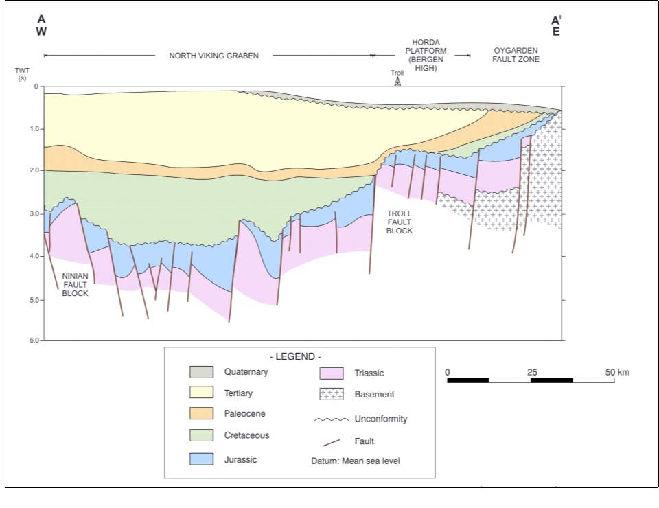
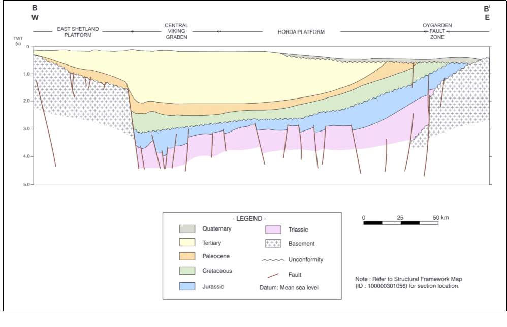
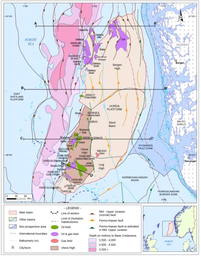
Note: Refer to Structural Framework Map (Figure 2.2.2) for section location.
2.3 Tectonic History
The evolution of the Horda Platform can be described by two distinct episodes of extension. The Early Syn-rift (Permian to Middle Triassic) extension resulted in a north-south trending “proto” North Viking Graben that traversed the Horda Platform. Major en-echelon faults with accumulated throws of up to 4 to 5 km controlled half-grabens, here major thicknesses of Pre-Triassic and Triassic sediments accumulated. The Main Syn-rift (Middle to Late Jurassic) extension took place in three major phases, Middle Callovian to Early Oxfordian, Late Oxfordian to Kimmeridgian and Early to Middle Tithonian. Late movement took place along the pre-existing north-south trending Triassic faults but most structural activity was along northnortheast-southsouthwest trending, west-throwing faults. These faults define the boundary between the tectonically active Viking Graben and the more stable Horda Platform. The tectonic history of the basin is outlined in Figure 2.2.1 and the structural framework is outlined in Figures 2.2.2 to 2.2.6
2.4 Petroleum Systems
2.4.1 Source Rocks
The Upper and Middle Jurassic shales of the Heather, Draupne and Drake formations and the Middle Jurassic coals and coaly shales of the Sleipner, Ness and Hugin formations have good potential as source rocks but none of these are mature on the Horda Platform, this is due to the depth at which these formations have been buried. All commercial hydrocarbons reservoired on the Horda Platform were generated in the Viking Graben mainly from shales, coaly shales and coals of the Draupne, Sleipner and Ness formations, these migrated up-dip via carrier beds and faults onto the platform.
The Drake Formation (Bajocian-Toarcian) has average Total Organic Content (TOC) of 2.88% with a Hydrocarbon Index (HI) of up to 415 mg HC/g TOC and a potential yield of 7.08 mg/g. Amorphous Type II/III kerogen predominates and these are good oil prone source rocks (Skjervoy & Sylta, 1993). On the basin flanks, according to Field (1985), Type IV-III kerogens predominate, these comprise gas and condensate prone vitrinite and inertinite.
The Ness Formation (Bajocian) consists of coals, coaly shales interbedded with fluviatile sandstones. The coal seams are generally thin, averaging 55 cm with a maximum thickness of 2.3 m. Average TOC is 56.83% and average HI of 309 mg HC/g TOC. Potential yield is 170.74 mg/g. The shales have an average TOC of 5.31%, a HI of 217 mg HC/g TOC and a potential yield of 11.52 mg/g. These are good potential source rock for gas and condensate (Skjervoy & Sylta, 1993).
The coals and coaly shales of the Sleipner Formation (Bajocian to Bathonian) and the Hugin Formation (Lower Bathonian to Lower Oxfordian) show TOC of up to 80% and HI of 200 to 400 mg HC/g TOC. HI figures can be confusing as much of the included kerogen can be inertinite, which has no source potential (Isaken et al., 2002).
The Heather Formation shales (Bathonian to Kimmeridgian) show average Total Organic Carbon (TOC) content of 2% to 3.6% and HI averaging 253 mg HC/g TOC. Potential yield is 7.94 mg/g. Kerogen is Type II-III with vitrinite predominating with minor quantities of exinite and amorphous sapropel. The most likely products are condensate and gas. This is a source rock of only moderate quality but it is very thickly developed in the North Viking Graben. If it is highly overpressured it can be an effective source rock due to extensive generated microfracturing, this aiding gas and condensate expulsion and migration.
The Draupne Formation hot shales (Oxfordian to Berriasian), which is the type equivalent of the Kimmeridge Clay Formation as used by Deegan and Scull (1977) in the Northern North Sea, are excellent potential oil source rocks. TOC averages 5% to 12% in basinal areas where HI ranges from 500 to 700 mg HC/g TOC. Oil-prone kerogen generated from algae and bacteria predominate. On the basin flanks TOC averages 2 to 5% with an HI range of 200 to 400 mg HC/g TOC. Thomas et al. (1985), suggests that spores and inertinite material predominate. There are considerable differences in source potential between the “hot” shales of the Upper Draupne and the “cooler” shales of the Lower Draupne formations.
Pre-Jurassic source rocks have also been penetrated on the Horda Platform. Well 25/10-2, drilled on the edge of the Utsira High, encountered oil shows in Zechstein dolomites and Rotliegendes conglomerates. The hydrocarbons in the Permian conglomerates are thought to have been sourced from the Kupferschiefer of the Zechstein Group (Pedersen et al. 2006).
2.4.2 Reservoir Rocks
The oldest Pre-Triassic reservoirs on the Horda Platform are the fractured basement rocks found in several wells on the Utsira High, these reservoirs are fractured granite and gneiss of Upper Ordovician to Archian age. An Upper Permian carbonate reservoir is also reported in the Johan Sverdrup Field on the Utsira High. The Triassic and Lower Jurassic reservoirs are reported in the Hegre, Statfjord, Johansen and Cook formation sandstones. Middle Jurassic reservoirs are reported from Sleipner, Oseberg, Etive, Ness, Tarbert and the Fensfjord formation sandstones. Upper Jurassic and Lower Cretaceous reservoirs are known from Sognefjord and the Intra Draupne sandstones. Within the Upper Cretaceous, hydrocarbons have been proven in a Tor Formation carbonates reservoir. Within the Rogaland Group the Paleocene turbidite sandstones of the Heimdal, Hermod and Balder formations are reported reservoirs. Within the Eocene (Hordaland Group) reservoirs are known from the Grid and Frigg formation sandstones. The, 2015, 026/10-01 (Zulu) discovery drilled in the Stord Basin has highlighted the hydrocarbon potential of the Miocene (Utsira Formation) sandstones and has opened up a new play in this area.
The Middle Jurassic Fensfjord and Sognefjord formation rift marginal sandstone wedges are the main reservoirs at the Troll field. The sedimentation and facies was controlled by the movement of the fault blocks at the Troll field during this time.
Movement of the fault blocks of the Troll Field during these periods controlled the sedimentation and facies of the Fensfjord Formation and Sognefjord Formation rift marginal sandstone wedges, which are the main reservoirs of the Troll Field. The deposition of the increasingly organic “hot” transgressive shales of the Draupne Formation marks the end of block faulting and the start of thermal subsidence.
The huge Troll field consists of three tilted fault blocks, Troll West Oil Province (TWOP), Troll West Gas Province (TWGP) and Troll East. TWOP has a 22 to 26 m oil column; TWGP has a 12 to 14 m oil column and Troll East a 0 to 4 m oil column. Oils are 24 to 28.9 deg. API with an average GOR of 360 scf/bbl. They are saturated and slightly waxy. Condensates are 40 to 44.9 deg. API. The gas is 93% methane and slightly biodegraded.
The very large Troll Field is located on the northwest edge of the Horda Platform (Bergen High), and lies to the east of the Oseberg field. It comprises three east-tilted, rotated fault-blocks extending over an area of 750 sq km. The controlling faults are north-south and north-northwest – south-southeast trending structures of Triassic age; these were rejuvenated during the three phases of Middle to Late Jurassic extension. There is a close relationship between the tectonic movement of the fault blocks and the sedimentology of the rift marginal Fensfjord and Sognefjord formations. They are the main reservoirs of the Troll field. The Troll structures are the result of Late Jurassic/Early Cretaceous fault movements and further modified in the Intra-Oligocene when relative subsidence in the east and west led to growth of the structures. Between the Intra-Oligocene and the Quaternary, structural closure decreased due to westerly tilting of the whole area.
2.4.2.1 Control of sandstone quality
None of the sandstone reservoirs of the Horda Platform have ever been very deeply buried. Therefore the diagenetic problems of secondary quartz and illite cementation which are a major problem in the Viking Graben are not so much of an issue on the Horda Platform. The main control on reservoir quality on the Horda Platform is the original depositional environment. Therefore, the coarse grained Triassic fluviatile sandstones are better reservoirs than the fine-grained sheetflood sandstones. Environmental facies are most important in marine shelf and near-shore sandstones where porosity and permeability quality increases with shallow, coarser grained, cleaner facies. This relationship was examined in some detail by IEDS (1994). In the Fensfjord and Sognefjord reservoirs of the Troll field, upper shoreface sandstones averaged 34.8% porosity and 2,104 mD permeability, while lower shoreface sandstones averaged 27.5% porosity and 186 mD permeability with shelf sandstones averaging 19.2% porosity and 1.92 mD permeability.
2.4.3 Seal
The two major regional seals in the Horda Platform are the shales of both the Heather Formation and the Draupne Formation. The lower part of the Heather Formation is generally an effective topseal to the Brent Group. It is often eroded on footwall crests, as in the western part of the Oseberg field, and in this case topseal is provided by the unconformably overlying shales of the Cromer Knoll Group and the Shetland Group. The upper part of the Heather Formation seals the Fensfjord Formation sandstones and the Sognefjord Formation sandstones in the Troll and Brage fields. The Draupne Formation shales are an effective topseal to the Sognefjord Formation sandstones in the eastern part of the Troll Fault blocks but are eroded in the western part of the Troll field where the topseal is formed by the shales of the Cromer Knoll and Shetland groups.
Most of the Triassic and Lower Jurassic reservoir sandstones in the Horda Platform are interbedded with or overlain by potential topseals. Additionally the Paleocene turbidite sandstones in both stratigraphic and structural traps are sealed by interbedded shales.
2.4.4 Traps
There is a wide spectrum of plays known and postulated within the Horda platform, these range from the Pre-Devonian structural play found in fractured basement rocks to the Paleogene and Neogene sandstones reservoirs found in structural, structural-stratigraphic and purely stratigraphic plays. By far the greatest majority of the known, to date and most productive plays fall in the age range dating from the Triassic through to the Cretaceous. The Jurassic/Triassic sandstone plays have Structural, Stratigraphic and/or unconformity traps, (or a combination of these three). The Cretaceous sandstone plays have Structural and/or Stratigraphic traps. Upper Permian carbonates and Upper Cretaceous carbonates are also known from the Horda Platform.
2.4.5 Migration
None of the potential source rocks found in the Horda Platform have been sufficiently deeply buried to generate significant quantities of hydrocarbons. Instead all commercial hydrocarbons reservoired on the Horda Platform were generated in the Viking Graben before migrating eastwards up-dip via carrier beds and faults onto the Horda Platform. The combination of extensive Jurassic sheet sandstones and gently tilted fault blocks provides an easy route for lateral migration of the hydrocarbons. Vertical migration via faults and through overpressured microfractured Cretaceous cap-rocks was necessary to source the Paleocene turbidite sandstones. Once in the fan sandstone complexes, long distance lateral oil migration up-dip into pinch-out plays is relatively simple to achieve.
There has been a great deal of discussion in the literature concerning the timing and migration routes of the oil and gas in the Troll Field. The gas is 93% methane and appears to be biodegraded. Horstad & Larter (1997) recognize two different oil populations. The oils in Troll West Oil Province (TWOP) can be linked with those of the Brage and Oseberg Alpha fields. While the oils of Northern Troll can be tied to well 31/2-8. The two oil families are mixed in Troll West Gas Province (TWGP). All of the oils are biodegraded. Chung et al. (1992) regard the Troll and Oseberg Alpha oils as isotopically heavy, these were late generated hydrocarbons that originated in the Troll Kitchen, Thomas et al. (1985) consider that the Troll Field was charged with oil prior to gas. Chung et al. (1992) think that most of the early generated oil has been displaced by later gas. Horstad & Larter (1997) consider that the Troll structures were first filled with gas generated from the lower part of the Heather Formation, from Statfjord Formation and Brent Formation coals. These were deeply buried in the North Viking Graben and generated gas during the Early Tertiary. In the Late Tertiary to Neogene, oil migrated into the structure from mature Draupne Formation source rocks in the North Viking Graben and biodegradation of both oil and gas took place. In the Neogene, westward tilting of the Troll structures resulted in rapid easterly migration of gas. During the Neogene to Recent, gas and oil charging is thought to have continued with rapid easterly migration of gas and some remigration of oil.
 2.4.6 Play Fairway Map
Figure 2.4.1 Play Fairway Map for the Horda Platform. (Modified after Zanella & Coward 2003)
2.4.7 Summary
2.5 Seismic attributes
2.6 Exploration History within the basin
2.7.1 1966-1969
The 1966 exploration well 25/11-01 was the first offshore exploration well to be drilled on the Horda Platform. This well was also only the second to be drilled offshore Norway. The primary objective of the well was to investigate the stratigraphy down to the basement in a Lower Tertiary regional structure. The well encountered 11 m of oil-bearing sand in the Lower Eocene.
2.7.2 1970s
In 1974, based on seismic data shot in the early 1970s, well 25/11-5 was spudded and penetrated a 24 m Paleocene oil-sand; this discovery is now known as the Balder Field. Balder is a large oil field comprising a submarine fan complex of middle to late Paleocene age where quartz-rich sandstones were deposited in a series of prograded and channelized supra-fan lobes. The reservoir is formed by eleven separate mound-like structures. On seismic sections, a nearly horizontal seismic event, a “flatspot”, was defined over the unallocated blocks 31/2, 3, 5 and 6. In 1979, the Troll discovery well 31/2-1AS confirmed that the flatspot coincided with a hydrocarbon-water contact. This well penetrated a 130 m thick gas column and a 12 m thick oil column. Seventeen seismic surveys were conducted over the Troll field in the early 1970s and 1980s. A large eastward-dipping structure that had been identified by seismic in block 30/6 gave rise to high expectation for the discovery of a major hydrocarbon find. The first well, 30/6-1 drilled in 1979, was relatively disappointing, being drilled in a structurally high position on the largest fault block, the Alpha structure. The well intersected a 68.5 m thick interval of Middle Jurassic, Brent Group gas-bearing sandstones with moderate reservoir properties. The Oseberg oil, gas and condensate field was discovered in September 1979 on the Oseberg Fault Block, it is the largest oil discovery on the Horda Platform.
2.7.3 1980s
The 30/3-2 Veslefrikk field discovery well was spudded in July 1980 and re-entered in 1981 to test what was designated as the Beta Horst. The well proved thin intervals of reservoir quality sandstones in the upper part of the Brent Group and low hydrocarbon saturations in the Dunlin Group reservoir. Two intervals were cored through the Brent: 2,828 – 2,849 m and 2,860 – 2,952 m. Veslefrikk is primarily a large Brent Group field on the northwestern rim of the Horda Platform. It was originally considered marginal but Statoil has recorded some success in expanding the field’s resource base through exploratory drilling from the Veslefrikk A platform. Veslefrikk was the first development off Norway to use a floating production unit. The Veslefrikk structure was discovered by 2D seismic data. A dense seismic grid has been acquired over the field, including more than 4,000 km of 3D seismic. During 1985 in the area of the Brage Field, 1,700 km of seismic was recorded at a line spacing of 200 m; this was processed by a 3D reconnaissance survey. Well 30/9-9 was drilled on the southern part of the J-structure, 3.5 km south of well 30/9-5 which in 1985 encountered a highly eroded Middle Jurassic Brent Group. The well reached a total depth of 2,980 m and reached its TD in the Triassic. It encountered a 7 m gas column and oil in the Lower Jurassic Cook Formation, the Statfjord Formation was found to be water bearing. The main objective of well 30/9-9 was to prove oil down-dip in sandstones of the Brent Group and the Cook Formation and to find an oil/water contact. A secondary target was to confirm the structural and sedimentological interpretation of the area. Oseberg East 30/6-5 was originally drilled to investigate a potential southern extension of the Veslefrikk field, but instead discovered a separate structure. Oseberg East comprises two structures separated by a sealed northwest-southeast fault: Beta South, discovered in 1981 by 30/6-5 and Beta Saddle, discovered in 1986 by 30/6-19ST. A 3D survey was carried out over Oseberg East from 1986 through to 1987. New-field wildcat 30/9-3 was plugged and abandoned as an oil discovery in March 1984. According to the NPD the discovery was not tested. However, side-track 30/9-3A, which was kicked off at 1,539 m in early March 1984, tested over 5,000 bo/d and is generally regarded as the discovery well of Oseberg South. In 1989, 30/9-8 defined the field’s southernmost limits. The 1981 oil discovery 30/6-4, found the Brent Group interval to be 88 m thick, with far better reservoir properties than in the three previous wells, the free water level was established in 1982. A 3D survey was completed between 1982 and 1983 across the Oseberg structures for the field development plan. The 3D survey covers an area of 530 sq km with 389 E-W lines of 65 m spacing. The Oseberg field is the third largest Norwegian oil field after Statfjord and Ekofisk and is located on the western margin of the Horda Platform.
2.7.4 1990s
A number of fields were discovered in the early 1990s. The giant Tertiary heavy oil Grane field was discovered in 1991. Svalin was discovered in 1992 and in August of the same year, well 025/08-04 discovered oil. During the following year well 016/01-04 found gas/condensate on the Utsira High. In 1994, Oseberg South J-Northeast and K-West structures were discovered.
2.7.5 2000s
In 2001 and 2002 respectively, the 30/6-26 oil and gas discovery and the R-Prospect 30/9-20 oil discovery were located in the northern part of the platform. In June 2003, on the Utsira High the 16/01-6s (Verdandi) oil and gas discovery was made. In 2003, the Ringhorne East, oil and gas field was found also on the Utsira High, the field has been producing since March 2006. The discovery well was 25/8-14S. The 16/4-4 (Biotitt) gas & condensate field was discovered in March 2007 on the Ling High in the south of the platform. The Edvard Grieg field (formerly Luno) was found in the same year; it is located in production licence PL 338, on the Utsira High and lies at a water depth of 354ft. The 16/2-3 Ragnarrock oil/gas discovery was found in 2007 along with the 25/11-24 (Midway) discovery. Exploration well 25/11-24 was drilled to test the Midway prospect on the Utsira High. The 16/1-12 (Edvard Grieg Extension), Edvard Grieg South is an oil discovery found in September 2009 on the Utsira High. In March 2009 the Stjerne discovery was found on the Bergen High (alternate name 30/9-22, Oseberg South). Also on the Bergen High was the 25/2-17 (Frigg Delta) discovery. The discovery well was drilled east of the Frigg Field and north of the Frøy discovery. The main objective of the well was to prove commercial hydrocarbon accumulation in the Frigg Formation found in the lower part of the Hordaland Group. The License obligation was to drill 50 m into the Rogaland Group, before setting the TD of the well (NPD, 2013).
2.7.6 2010–2018
The Utsira High’s 2010 discovery Johan Sverdrup (16/2-6 & 8), a giant oil field, is thought to be one of the top 10 largest discoveries on the NCS. On 17 January 2012, the Norwegian Minister of Petroleum and Energy Ola Borten Moe announced that the Aldous/Avaldsnes discovery was to be re-named the Johan Sverdrup field. The choice of name is thought to reflect the importance of the project and the operations now being conducted. (Norwegian Ministry of Petroleum and Energy, Jan 2012). The 16/7-10 (Theta NE) gas & condensate field was discovered in September 2011. The field now at the appraisal stage was discovered in the south on the Ling High. The 16/2-9s (Aldous Major North) oil discovery was found in September 2011 on the Utsira High. On the Oseberg Fault Block 30/6-28S (Crimp) discovery was found. Crimp is a small oil field located in close proximity to Oseberg Field. At the time of the discovery in March 2012 Statoil estimated recoverable reserves to be in the region of 12-18 MMboe. Luno, one of the largest oil finds in the Norwegian North Sea in the last decade, was re-named to Edvard Grieg in April 2012. Another discovery on the Utsira High is the 16/4-6S (Luno II) oil and gas field which was found in April 2013 this was followed in August of the same year by the 016/2-14S (Cliffhangr North) discovery. In February 2015, 26/10-1 (Zulu) was found in the Stord Basin, this was followed in April by the Utsira High discoveries 25/6-5S (Skirne East) and 16/4-9S (Luno II North). In September 2015, the 30/9-27S oil discovery was followed in February 2016 by the 30/9-28S (B-Vest) gas discovery; both were found in the Oseberg Fault Block.
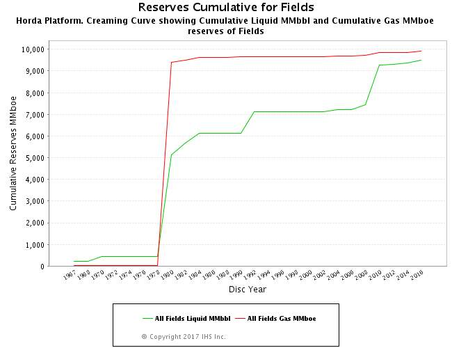
Figure 2.7.1 Creaming curve for the Horda Platform. (Modified after IHS Markit, 2016)
Chapter 3 – Data set and Methodologies
3.1 Location and amount of data
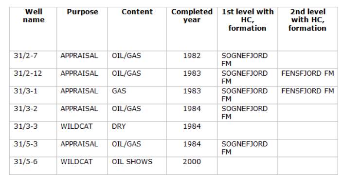
The dataset has kindly been provided by the Norwegian Petroleum Directorate (NPD). The project area is a 3D cube shot by Norsk-Hydro (now Statoil) in 2003 covering an area of around 1,200 sq.km on the Bergen High including the Troll field (Figure 3.1.1). The survey covers 30 exploration and appraisal wells but only seven have been made available for the purpose of this project. An overview of the available wells is provided in the table overleaf.
3.2 Nature and quality of data
The 3D data is mostly of good quality having been shot fairly recently in 2003. The data cube contains a total of 1,700 inlines and 2,800 crosslines. The 3D data has been tied in using the well data provided and can therefore be accurately depth converted. Structural features and seismic facies can be easily picked out to allow for a better interpretation of the data. No previous work had been done to the dataset before it was received, and all interpretation is original and my own. An example seismic line can be seen in Figure 3.2.1.
3.3 – Workflow
3.3.1 Software
IHS Kingdom 2017 (64 bit) software was used for all seismic interpretation work and associated analysis. The Kingdom software is a windows-based interpretation tool designed by IHS Markit. Kingdom allows for an integrated analysis of seismic, well and reservoir data.
3.3.2 Data loading
All of the data was supplied in its raw format. The seismic data was in SEG-Y format while the well data was provided in LAS (composite logs) and ASCII (deviation surveys, log curves and well header information) format.
Before loading the 3D data the survey extents and world co-ordinates must be extracted. The starting byte location for the inline/crossline numbers and for trace XY co-ordinate values must be defined. This data can often be found in the trace headers from where it can be extracted during loading. The survey will not be projected onto a base map until the world co-ordinates have been entered. The well data was directly imported using the well explorer.
3.3.3 Seismic interpretation
When performing seismic interpretation it is best practice to pick all of the faults before commencing horizon picking. The 3D data was interpreted using the following work flow:
- Pick all fault segments to understand the relationship with the seismic stratigraphy. Faults can be either unassigned or assigned to a named fault surface.
- Identification and interpretation of mega-sequences (pre, syn and post-rift) based on geometries and seismic facies.
- Perform seismic well tie before commencing horizon picking. Sonic and density logs were used to create a synthetic seismogram and the seismic reflectors were time shifted.
- Guided auto tracking was the preferred method for horizon picking although a 3D hunt was performed in some areas using a polygon autopick per fault block (after fault polygons have been created).
- Create fault polygons, either manually or automatically. The automatic option is useful whenever the fault surface is easily picked and smooth.
- A polygon hunt can now be performed. Before using the 3D Hunt autopicker it is important to pick several lines so that the autopicker has some seed points with which to begin the iterations. In areas where the polygon hunt is struggling it will be necessary to manually interpret the data.
- Grid interpreted surfaces to enable the creation of time structure maps.
- Create thickness maps to further understand the basin tectonic evolution and spatial distribution of prospective reservoir sections.
- Analysis of seismic for amplitude anomalies or any other direct hydrocarbon indicators (DHI) which may suggest the presence of a hydrocarbon accumulation.
- Calculate volumetric parameters of identified prospects and generate potential resources.
3.4 Limitations
As in most seismic studies, seismic resolution and data coverage may be regarded as the main limitations. Although the seismic is of good quality, by its very nature the data inherently holds initial limitations of quality. This is due to a combination of seismic processing, detection limits and resolution issues (Herron, 2011). The detection of the seismic signal is bounded by the signal to noise ratio, while the resolution depends on the wavelength (Brown, 1999). At greater depths wavelengths become longer and therefore the resolution of the seismic becomes diminished.
Limitations of the data include the difficultly in following certain horizons across the dataset due to complex geometries and phase changes induced by hydrocarbon saturation. For example the Sognefjord Formation, which is the primary reservoir in this area, has a phase change across the hydrocarbon saturated zone of the Troll field within the study area (Figure 3.4.1). Herron (2011) noted that a phase change to a peak within the Sognefjord Formation is common when it becomes saturated with hydrocarbons.

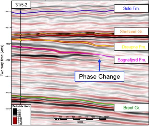
Brent Group
3.5 Depth conversion
Depth conversion is important when performing interpretation of seismic data as it allows for the correct measurement of geometrical features. Depth conversion is the process which converts the two-way travel time (TWT) of an acoustic wave into a depth value. The conversion requires the acoustic velocity of the different intervals intersected by the well. Where this data is not known the Kingdom software calculates the interval velocity using the following equation:
Due to the number of wells drilled within the survey area it has been relatively simple to depth convert the data. Figure 3.5.1 shows a calibration curve for well 31/2-7. However, several limitations must be considered when depth converting data. The main issues to
be considered include the lack of data at deeper levels and the distance between the wells used to tie the seismic. Additionally, a number of the wells in the dataset have penetrated hydrocarbon saturated intervals which in turn can reduce the seismic
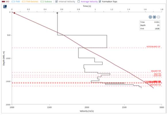 velocity.
Chapter 4 – Data set and Methodologies
3.1 Location and amount of data
Cite This Work
To export a reference to this article please select a referencing stye below:
Related Services
View all


Related Content
All TagsContent relating to: "Energy"
Energy regards the power derived from a fuel source such as electricity or gas that can do work such as provide light or heat. Energy sources can be non-renewable such as fossil fuels or nuclear, or renewable such as solar, wind, hydro or geothermal. Renewable energies are also known as green energy with reference to the environmental benefits they provide.
Related Articles

DMCA / Removal Request
If you are the original writer of this dissertation and no longer wish to have your work published on the UKDiss.com website then please: