Argos System: Radar, Radio Navigation and Location Systems
Info: 9176 words (37 pages) Dissertation
Published: 9th Dec 2019
Tagged: CommunicationsEngineering
ARGOS SYSTEM: TECHNOLOGY AND APPLICATIONS
RADAR, RADIO NAVIGATION AND LOCATION SYSTEMS
Table of Contents
2. Overview of Argos Technology
2.1 Argos’ main characteristics
3. International collaboration
3.1 CNES: Centre National d’Etudes Spatiales
3.2 CLS: Collecte Localisation Satellites
3.3 NOAA: National Oceanic and Atmospheric Administration
3.4 EUMETSAT: European Organization of the Exploitation of Meteorological Satellites
3.6 GEOSS: Global Earth Observation System of Systems
4.1.4 Monitoring water resources
4.2 Protecting public health and wellbeing
4.3 Improving maritime security
5.1 Price comparison with other technologies in the market
List of figures
Figure 1 Doppler effect in Argos system.
Figure 2 Geometric location principle.
Figure 3. NOAA POES spacecraft with Argos/DCS instruments. (Credit: NOAA)
Figure 4. The Argos processing centers (image: Service Argos Inc.)
Figure 5. Argos Platform transmitter terminals
Figure 6. Bird equipped with miniaturized Argos System
Figure 7 GPS integration with Argos system (source: woods hole)
Figure 8. Message handling scheme of the Argos-2 (image: NOAA)
Figure 9. Message handling scheme of the Argos-3 (image: NOAA)
Figure 10. Argos-4 instrument During test (source: CNES)
Figure 12. Number and type of Argos platforms around the world.
Figure 14. Argo floats around the world. Source: NOAA
Figure 15. GTS system obtaining maritime information through Argos system
Figure 16 Asia elephant with Argos system
Figure 17. Eagle migration studied by Argos system.
Figure 18. The Mentor Initiative Logo.
List of tables
Table 1. Satellites in service and their launch date
Table 2. C comparison of Argos classes and GPS
Table 3 Comparative analysis of the three generations
Table 4 Comparative analysis of the three generations [17]
Table 5 Total cost and cost per data point of different wildlife tracking case studies [14]
1. Introduction
Argos is a satellite-based system in charge of collecting environmental data from autonomous platforms (Any equipment integrating an Argos-certified transmitter) and delivering it to users worldwide. Argos system locates the source of the data anywhere on the earth by utilizing the Doppler effect.
Argos was launched in summer 1973 by Richard Tompkins. The system has become operational worldwide since 1974 and was initiated jointly by the cooperative program between the French Space Agency CNES and the North American NASA. In 1978 the Argos system package has been flown on all satellites of NOAA (National Oceanic and Atmospheric Administration) and service to the user community has been continuously provided. The processing and distribution service is provided commercially by CLS (Collect Localisation Satellites).
The Argos system helps industries to comply with environmental protection regulations implemented by various governments and is also used by the scientific community to better monitor and understand our environment. Argos Systems is used by several space agencies worldwide and it has a wide range of applications.
This document is divided in 4 parts. First, an overview of Argos Technology and its characteristics is presented, followed by the explanation of the system components as well as the evolution over the years. Next, the document moves on to explain the international collaborations and some of the possible applications the system is used for. Finally, the document presents some pricing policies for acquiring the system.
2. Overview of Argos Technology
In Argos system the platform transmitter terminals (PTT) are used for data transmission, automatically transmit messages that are received by the Argos satellites. Messages received by the satellites are then transferred to the ground stations and then to the Argos processing center. Where the data are processed and the position of the transmitter is located. This processed data is then directly transmitted to the users through multiple methods such as Argos websites, Argos servers (Telnet) and Argos direct automatic distribution (e-mail, Fax, CD ROM, etc.)
In Argos system location can be calculated by Doppler effect, however the newest systems can have a GPS integration for a more accurate positioning.
The frequency band used by Argos system is 401.650 MHz ± 30 kHz, which is stable for the location calculations computed on the basis of Doppler effect measurements.
Thanks to the Doppler effect and as it can be observed in figure 1, when the satellite approaches a transmitter, the frequency of the transmitted signal measured changes with the movement of the satellite. When the satellite is approaching the Argo transmitter the measured frequency is higher than the actual transmitted frequency and is decreases when it moves away.
Every time a message is received at the satellite from an Earth transmitter the frequency and the time tag intervals are measured.
The advantages of Doppler location are low transmitter power consumption and instant location opportunities throughout satellite passes.
Moreover, two processing algorithms are used for more accurate location calculation through Doppler effect:
- Least square analysis
- Kalman filtering
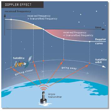
Figure 1 Doppler effect in Argos system.
Source: www.argos-system.org
On one hand, in the “least square analysis” represented in figure 2, an initial platform position estimation is computed from the first and last messages collected during a single satellite pass and the last computed frequency of the transmitter.
As it can be observed in figure 2, from these initial measurements two possible solutions of the real position of the transmitter appear. This estimation is further refined by doing a least-squares analysis using all the messages received during the satellite pass over the platform.
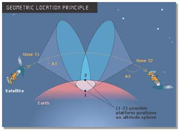
Figure 2 Geometric location principle.
Source: www.argos-system.org
On the other hand, location detection with Kalman filtering algorithm is a two-step process:
- First step. Based on previous position and estimated errors, this filter predicts the next position and estimated error.
- Second step. By using frequency measurements during the satellite pass the filter is able to calculate the new position and its estimated error which allows the update of the previous predictions.
Another way for improving location accuracy is the use of GPS. In GPS based Argos location estimation, the positions are more accurate and do not depend on transmitter quality, also location can be collected more regularly over the day. In GPS location estimation, The PTTs are much more complex than standard PTTs, each unit is programmed with two independent duty cycles. The local time is defined by the first cycle, the second cycle commands the GPS data through the Argos system.
2.1 Argos’ main characteristics
Although there are other positioning systems in the marker Argos has some key characteristics that make it unique.
- Worldwide coverage. The system allows any mobile object equipped with the appropriate Argos transmitter can be located across the globe, from pole to pole. The Argos system is composed of a constellation of satellites providing global coverage, including the equator and poles. A network of 60 ground stations enables Argos users to receive their data in near real-time.
- Robust system. Robust security solution to protect IT infrastructures and data.
- Clear purpose. Argos is a worldwide data and location collection system dedicated to study and protect the environment.
- Low power transmission optimized for longer lasting devices and lower battery consumption.
- Miniaturized transmitters. The newest Argos transmitters have increased in size permitting a wider range of applications such as small animal tracking and monitoring.
- Argos also provide the possibility of collecting data from other sensors that are connected to Argos transmitter.
- Dual positioning system. Argos provides the best satellite-based Doppler positions available for wildlife tracking. The advantages of Doppler location are low transmitter power consumption and instant location opportunities during satellite passes (which is useful for tracking marine animals for example). In addition, transmitters can be equipped with GPS receivers and send GPS positions via the Argos system.
- Data archiving. CLS’s robust data center ensures that once your data is collected by the Argos system, it will never be lost. Backed up in three distinct sites, CLS is a leader in protecting information systems and archiving of data.
- Multiplatform. Argos system has both an Android and a computer Software from where users can track their devices in an easier manner. ArgosWeb allows users to export their data to Google Earth.
2.2 System Architecture
The Argos system concept involves three interactive elements or subsystems: the space and ground segments and the platform transmitter terminals or PTT.
2.2.1 The space segments
The initial Argos constellation was comprised of 5 satellites. Later on one new satellite was added to the constellation.
The two basic service satellites were provided by NOAA-16 and NOAA-17, and the three secondary satellites are provided by METOP-A, NOAA-18 (N) and NOAA-15 (K). From 2009 onwards other three basic satellites are launched that are SARAL (2009), METOP-B(2012) and NOAA-N’(2013), as illustrated in Table 1. Satellites Global and Regional datasets they collect are delivered according to the “multi-satellite” service characteristics.
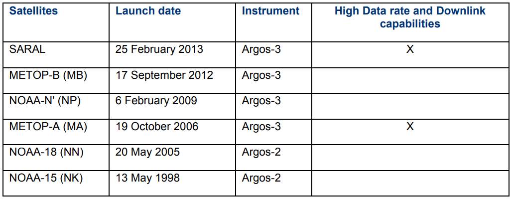
Table 1. Satellites in service and their launch date
These six satellites are in 100 min, near polar, Sun-synchronous orbits that are each offset from the other satellite orbits, so that they cover as much ground as possible on each day. Areas at the poles see the transmitter on each pass, acquiring 14 data takes per day, while areas at the equator get around 8–10 per day, day or night, rain or shine. Each orbit overlaps 25 % at the equator with the last pass, as shown in Figure.1 as Earth rotates under the satellites in a polar orbit.
Each satellite covers an area 5,000 km across as it orbits Earth and can receive data from all Argos transmitters within this area. The satellite will be in view of a platform for approximately 10 min, but it only takes a second to transmit and receive the data.
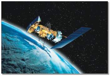
Figure 3. NOAA POES spacecraft with Argos/DCS instruments. (Credit: NOAA)
2.2.2 The ground segments
As of 2002, the Argos provides five processing centers (the two global processing centers in Toulouse and Largo continue to process data sets from all receiving stations; the regional centers are in Melbourne, Tokyo, and Lima. More than 1000 data sets per day (100 STIP data sets, 900 Real-time data sets) are processed in each center.
In Argos the message transmission intervals range from 90 – 300 s, depending on the application. The ground receivers receive the data while in view of a ground station can download the data in near real time.
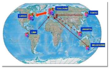
Figure 4. The Argos processing centers (image: Service Argos Inc.)
Argos provides a total of four parallel receiving channels for data collection, each at a rate of 400 bit/s. The Argos communication capability is limited to the function of data collection from the PTTs. The concept does not offer a remote configuration control capability of the data collection platforms in the ground segment.
The three regional processing centers only process data sets from stations within their region. Supplementary data, providing global coverage is supplied by the Toulouse center or by the Largos center, if necessary. The number of operating Argos platforms continues to increase. The format of Argos messages are sequences of binary digits. The data contained in these messages are first processed and then distributed by the Argos system to the respective users. The processing system can handle several message formats for one transmitter. A message format is a specific type of message with specific structure that is sent by an Argos platform.
- Platform Transmitter Terminals (PTT)
PTTs are installed at the ground segments of every client at fixed or mobile positions, deployed at sea, on land, or in the air. All platforms, reporting to the Argos system must carry a certified PTT package for satellite uplink communication. Each PTT sends a short message (of 0.36 to 0.92 seconds duration, or of 32 bits to 256 bits maximum length) modulating a carrier frequency.
Argos-1 and 2 were equipped with PTTs, while from Argos-3 onwards it has been changed to PMTs (Platform messaging transceiver). The PMT is capable of sending and receiving messages to/from satellite, at the same time, as well as processing commands. Before the PMTs, Argos was a one-way communication system. The PMT is fully compatible with all satellites of the Argos constellation and can also be used like a platform terminal transmitter (PTT). The use of PMT improved the cost, the consumption and lifetime as well as the size of Argos platforms.
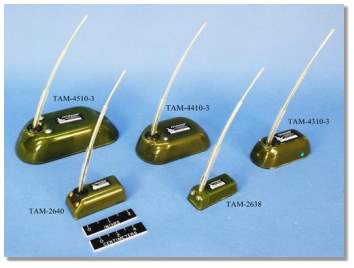
Figure 5. Argos Platform transmitter terminals
Argos system use ISM band frequency of 401.650 MHz ± 30 kHz, which must be stable as the location is computed on the basis of Doppler effect measurements.
One way for improving location accuracy is the use of GPS. In GPS based Argos location estimation, the Positions are more accurate and do not depend on transmitter quality, also location can be collected more regularly over the day. In GPS location estimation, The PTTs are much more complex than standard PTTs used in ordinary Doppler positioned Argos system. They consist of four major subsystems: a GPS receiver, a microcomputer and antenna, an Argos uplink transmitter and a solar charged battery.
Argos PTT have different shapes and formats depending on the application they are designed for. From drifting or moored buoys to the smallest transistors for animal tracking, Argos PTT vary in shape and size to cope with the different necessities. Nowadays, new PTTs are available in much smaller size and light weight. For example, The PTTs used in Birds tracking applications are of a size of 30 grams, 22 grams, 17 grams or even 3.5 grams. As shown in figure 4 below.
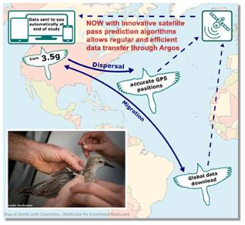
Figure 6. Bird equipped with miniaturized Argos System
Source: https://www.lotek.com/pinpoint-argos.htm
- GPS integration with the Argos system
To provide a better location accuracy in all classes where accuracy is required, some changes to the system have been made. Standard locations that comprise of classes 3, 2, 1, and 0. Class O locations have failed certain quality control checks, thus, there is no upper limit on their accuracy. Other classes like Class A, B and Z have less than 4 messages and are available under a separate service, Auxiliary Location Processing.
Now a days Global Positioning System (GPS) positions are processed along with Argos locations through the Argos system. The fact that GPS receivers continuously recalculate position fixes, higher temporal resolution is possible. Recent developments in the Argos system allows the GPS data in the animal-borne Argos–GPS unit to be used with on-board orbital prediction programs enabling transmissions only during satellite overpasses. This increases data transfer and power efficiency for the system. As illustrated in the Figure 5 a GPS receiver is interfaced into the Argos transmitter, the GPS position can be extracted from the Argos messages using a dedicated processing module at the Argos centers.
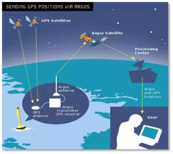
Figure 7 GPS integration with Argos system (Source: woods hole)
One of the geographical limitation with Argos is that noise in the environment in Europe and Mongolia–Pakistan disrupts data transfer on the Argos uplink frequency, To limit this problem, authorities are using international agreements to protect satellite uplink frequencies, that include highly modified antenna designs and also using high power Argos transmitters to achieve higher radiated power for a functional satellite link.
As the Argos system uses different classes, such as the standard locations comprise of classes 3, 2, 1, and 0. Class 0 locations have failed certain quality control checks, thus, there is no upper limit on their accuracy. Other classes like Class A, B and Z have less than 4 messages and are available under a separate service. A comparative analysis of these classes and also the GPS is given in Table 2.
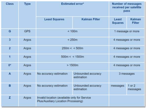
Table 2. C comparison of Argos classes and GPS
2.3 System Evolution
2.3.1 Argos-2 DCS
This is the next generation package of the Argos system. It represents an enhancement over the old Argo system, in response to user identification priorities. The new system improvements include:
- Eight DRUs (Data Recovery Units) were Implemented instead of four on the previous Argos generation in order to process eight massages simultaneously.
- Uplink bandwidth was increased from 24 to 80 kHz. Which permitted a better distribution of PTT transmitter frequencies and a better discrimination of signal reception at the spacecraft. The more flexible management of transmitter repetition, the increased capacity and the wider receiver bandwidth, offers more PPT sensor data transmissions.
- Greater sensitivity to signals transmitted at low power. The impact of the higher sensitivity (from -128 to -131 dB) are broad in scope in that the general population of Argos transmitters will require less power.
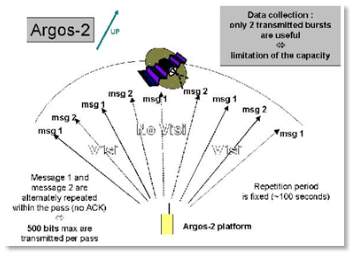
Figure 8. Message handling scheme of the Argos-2 (image: NOAA)
PMTs (Platform Messaging Transceivers) are being introduced for the first time by the ground segment platforms (PTTs) able to receive and interpret messages sent by the satellite. NOAA-15 was the first Argos-2 system, satellite package that was launched on May 13, 1998.
2.3.2 Argos-3 DCS
This system is also referred to as Advanced Data Collection System (ADCS). The main objectives that paved the way for the Argo-3 system are:
- To improve the performance of the Argos system in terms of waiting time and overall data collection capability.
- To provide users with the downlink message function, validated by the Argos-Next instrument installed on JAXA’s ADEOS-II (now out of service), namely a space-to-earth link dedicated to the transmission of messages to the Argos Platforms fitted with appropriate receivers.
This system defines two transmission modes depending on the targeted applications, the Low Data rate (LD) and High Data rate (HD). In the high data rate (HD) mode the physical data is sensed by the DCPs producing a bit stream operating at 4800 bps, it is then encoded using a convolutional code and transmitted employing Gaussian Minimum Shift-Keying (GMSK) modulation at 401.595 MHz. In Argo-3 the length and the repetition period of the messages are used according to the user needs.
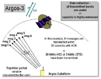
Figure 9. Message handling scheme of the Argos-3 (image: NOAA)
The Argos-3 terminals use different modulation waveforms: BPSK, QPSK, and GMSK, channel coding, data volumes and bit rates with a good stability oscillator for the Doppler location. The new system is able to send orders to its terminals, whereas before they were capable of receiving data only. In Argos-3 a new version of the instruments was used for management and processing software in 2004 and was tested extensively, at satellite level by Astrium, and in conjunction with the operational ground segment by EUMETSAT.
2.3.3 Argos-4
The mission of Argos system is always to offer a new system which will give connected objects an entirely new dimension. Due to the recent surge in Internet of Things (IoT) technologies, the Argos system is making the IoT available for all over the world. In order to achieve this feat, data analytics, Big data and data mapping will need to be taken into account for this entirely new generation ARGOS system.
The new program for the next generation Argos (Argos-4) was started by CNES (Centre National d’Etudes Spatiales). The 1st Launch of Argos-4 will be in 2018 (Oceansat-3), and other launches through EUMETSAT (Metop-SG) and NOAA (USAF Hosted Payloads). Argos is developing new instruments, technology and components up-to date and software fully rechargeable on-board for the next generation Argos-4 system. Due to this new technology the capacity will be increased by 4 times and the power will be reduced to approximately 150 mWatt.
Figure 10. Argos-4 instrument During test (source: CNES)
A new ESA project called shark project is now working to implement ARGOS-3 and ARGOS-4 capabilities on-board an Integrated Circuit. Such component will be provided at very low cost to all Argos manufacturers and will work at very low power.
A comparative analysis of all the three generations of the Argos systems is summarized in Table 3.
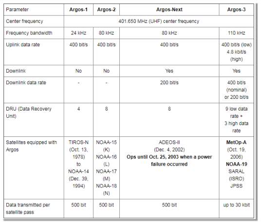
Table 3 Comparative analysis of the three generations
3. International collaboration
As previously introduced, Argos was launched in 1973 by the cooperative program between the French Space Agency (CNES), NASA and the National Oceanic and Atmospheric Administration (NOAA). A few years after two subsidiaries were created to operate, maintain and commercialize the system. CLS in Europe and North American CLS in the USA. Both companies have merged in CLSAmerica.
Nowadays, several other space agencies around the world participate in the Argos system such as EUMETSAT (European Organization of the Exploitation of Meteorological Satellites), the ISRO (Indian Space Research organization) or GEOSS (Global Earth Observation System of Systems).
3.1 CNES: Centre National d’Etudes Spatiales
The French Space Agency was one of the founders of Argos. Nowadays, CNES is the Argos system architect and oversees development of its ground and space components.
In addition, in August 2017, CNES announce that it was launching a new project called Argos ANGELS (Argos NEO Generic Economic Light Satellites). This new feat would include the development of new miniaturized Argos instruments, Argos NEO developed Syrlinks that will fly on board of the first French nanosat. [6] [7]
The Argos ANGELS satellite is planned to launch in 2019 and will mix satellite telemetry and space-borne IoT in order to prototype a new Argos constellation aiming to prove the capabilities of a complex and smaller instrument providing higher performance.
3.2 CLS: Collecte Localisation Satellites
CLS in Toulouse and its subsidiary in the U.S., CLS America are in charge of the operation, maintenance and promotion of Argos system and have been providing satellite-based solutions for environmental and location data collection for over 30 years.
Two of the latest projects CLS has joint in 2018 include, contributing to the United Nations plan to stop Illegal Fishing by 2020 or integrating with the newest version of EO4wildlife platform for animal monitoring.
3.3 NOAA: National Oceanic and Atmospheric Administration
Scientific agency of the Commerce Department of the USA focused on the state of the atmosphere and the oceans. NOAA:
- Tracks and warns if dangerous weather is detected.
- Creates maps of the oceans and the sky.
- Explains how to use and protect both the ocean and the costal resources.
- Practices scientific investigation in order to better understand and manage the environmental resources.
3.4 EUMETSAT: European Organization of the Exploitation of Meteorological Satellites
EUMETSAT is the European operational satellite agency in charge of monitoring the climate, environment and weather by observing the atmosphere, ocean and land surfaces through a system of meteorological satellites. The data collected by this system is supplied to many users worldwide, including the National Meteorological Services of the organization’s Member and Cooperating States in Europe.
Argos system is part of the current generation of EUMETSAT’s Metop satellites and thanks to an agreement signed in 2016 it will also be part of Metop Second generation satellite, ensuring the continuation of this data up to 2040. [8]
3.5 ISRO
The Indian Space Research Organization (ISRO) is the primary space agency of India and one of the most important space agencies worldwide.
SARAL is a joint Indo-French satellite mission which aimed to study the oceans. This satellite includes Argos-3 system and it is in charge of collecting a variety of data from ocean buoys and other elements in the ocean with Argos transmitters to study ocean circulation and sea surface elevation.
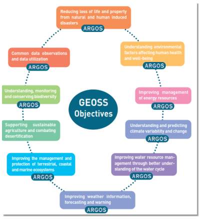
3.6 GEOSS: Global Earth Observation System of Systems
Argos and GEOSS in future, Argos will be an important part of GEOSS, the Global Earth Observation System of Systems.
GEOSS is an international initiative approved by over 60 governments and the European Commission and designed to improve our understanding of the Earth system. This initiative’s main goal is to modernize and optimize existing systems such as data processing or dissemination.
GEOSS intends to partner with all countries around the world and to cover space based, in situ and airborne observations. Some its objectives are the following:
Source: (https://www.igp.de/images/broschueren/ARGOS%20Presentation.pdf)
4. Applications
Argos’ unique worldwide location and data collection systems are primarily dedicated to study and protect the environment. Thousands of Argo transmitters are in use nowadays and the system is capable of supporting more.
The number of application is very broad however all the programs using Argos have to be related to environmental protection, study, awareness or protecting human life. Some of the most important applications and its technology will be explored in this section of the document.
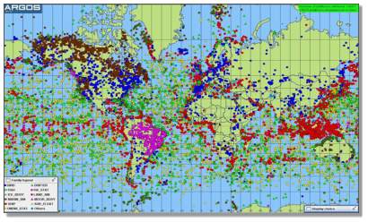
Figure 12. Number and type of Argos platforms around the world.
Source: (https://www.clsamerica.com/using-argos)
4.1 Environmental monitoring
In order to better understand the causes and predict the evolution of climate change thousands of buoys, floats and fixed stations worldwide are equipped with Argos beacons. Data such as wind speed and direction, air pressure, air temperature, water salinity and temperature are collected all around the world.
4.1.1 Oceanography
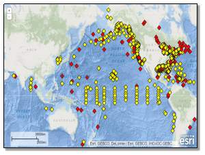
In oceanography, data is collected to improve ocean current forecasting or to collect in situ data. For example, the Argo program (do not mistake it with the Argos System) is one of the most active programs around the world. As part of the GOOS or Global Climate Observing System, is in charge of collecting temperature and salinity profiles from the ice-free ocean. Argos beacons are an essential part of this system, helping to collect these oceanographic measurements and indicating the location they were taken at.
Argo floats descend to a target depth of up to 2000m to drift and after 10 days, they rise to the surface collecting temperature, salinity, and other data that are transmitted via satellite when the float reaches the surface. This observation cycle can be repeated for several years until the batteries run out. For floats using Argos, a series of 200 measurements of pressure, temperature, and salinity are taken.
Figure 10 is a clear representation of the collecting data process done by Argo floats and figure 11 shows the high presence of Argo floats around the world.
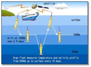
Figure 13. Observation cycle with Argo floats. Source: (https://www.jamstec.go.jp/e/about/press_release/20160129/)
Furthermore, Argos offers ocean data telemetry services for applications such as ocean modelling or surface currents mapping. Both Argos and Argos with GPS system are installed in buoys to measure the movement of the water masses which is very valuable for ocean current forecasting. In 2016, the Japan Agency for Marine-Earth Science and Technology announce that after 15 years of observations Argo’s global array of profiling float revealed ocean changes. [9]
4.1.2 Meteorology
Additionally, meteorologists also use Argos to gather information. This useful data is used in programs such as World Weather Watch in which data is exchanged on a voluntary and global basis for insertion into numerical weather and ocean prediction models via Global Telecommunications System.
The Global Telecommunication System (GTS) is defined as: “The co-ordinated global system of telecommunication facilities and arrangements for the rapid collection, exchange and distribution of observations and processed information within the framework of the World Weather Watch.”
Satellite-based data collection systems, including Argos are integrated in the GTS as an essential element in observational data collection from Data Collection Platforms.
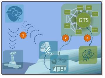
Figure 15. GTS system obtaining maritime information through Argos system
Source: http://www.jcommops.org/dbcp/platforms/telecomms.html
4.1.3 Wildlife monitoring
Thousands of aerials, marine and terrestrial animals are fitted with miniaturized Argos transmitted and tracked worldwide. The data collected by Argos, allows biologists to better understand animals’ behaviour: breeding, feeding strategies, adaptation to their environment, etc. Those observations are particularly valuable when it comes to endangered species. Despite to its ecological value, this work allows the international community to learn more about our environment’s natural resources and interactions between humanity and wildlife.
With the newest advances in the Argos technologies, the beacons positioned in the animals and becoming smaller and lighter, resulting in less uncomfortable devices to carry by small animals such as birds. With accuracy of between 250m and 1.5 kilometres they do not have the pinpoint accuracy of GPS but have the advantage of being a much smaller unit.
From elephants to shorebirds, nearly 8000 animals are track every month with Argos:
- Birds. Thanks to the shrink in Argos transmitter, the possibility of tracking new smaller species, such as small birds that can now carry the weightless transmitter.
- Terrestrial animals. About 2000 land mammals are tracked every month by scientist thanks to Argos. Argos provides very robust equipment that can cope with the most extreme environmental conditions specially design for each specie. Big mammals such as elephants or bears are usually instrumented with big collars design to be specifically durable because of the animals’ size and strength and due to external conditions.
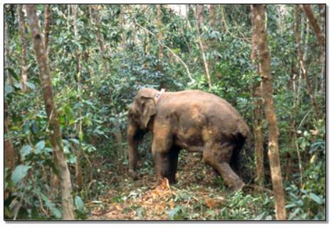
Figure 16 Asia elephant with Argos system
Source: http://www.telonics.com/products/specialty/elephant.php
- Marine animals. The future of the marine ecosystem depends largely on our ability to preserve it effectively. A wide range of marine animals are nowadays equipped with Argos system to understand their geographical distribution and trajectories. Endanger marine animals such as turtles carry Argos transmitter for scientist to understand their behaviour and ultimately preserve the specie.
Despite of the challenging external conditions Argos transmitters can record for may months the temperature and depth of the water.
Other interesting applications is the use of Argos transmitters on fishing vessels to monitor exclusive economic zone (EEZ) compliance. These vehicles monitoring systems or VMS provide data that is admissible in court regarding illegal fishing and are used around the world to monitor fish catch data. The Argo system provides a turnkey package monitoring fishing fleet operation. Nowadays over 8000 fishing vessels around the world are equipped with this technology and several nations have successfully prosecuted illegal fishing operations within their EEZ limits.
Latest study:
Argos’ system most recent publicised article related to wildlife tracking is one that has studied the migration of eagles in Africa. In the following figure we can see some of the results. Argos wildlife tracking helps to understand the best conditions for young and adult lesser spotted eagles to survive their 10,000-km long migrations. Using Argos PTTs, over 100 birds have been followed since 1992.
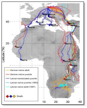
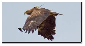
Figure 17. Eagle migration studied by Argos system.
Source: http://www.argos-system.org/applications-argos/wildlife-monitoring/
4.1.4 Monitoring water resources
Freshwater resources and supplying water for the world’s population are increasingly important issues. Nowadays water in lakes, wetlands, and rivers is only 0.3% of the world’s freshwater.
The loss of freshwater resources has impact on many other main issues as food availability, public health or climate, and can result to environmental disasters.
International monitoring programs are using Argos to relay key data such as water level of rivers or snow covers. These information networks will help the global community to better manage existing water resources and implement more efficient and useful resources of available water.
4.2 Protecting public health and wellbeing
In developing countries, the risk of epidemic outbreak and food shortage is high. However, surveillance systems capable of detecting early warning signs are often missing. Argos terminals are used by many humanitarian aid programs to relay crucial information from remote areas. In Africa
and the Middle East, Argos terminals are used to monitor school attendance and food distribution data. Argos terminals are also used for early detection and warning of communicable disease outbreaks, by relaying information about caseloads and drug availability from remote areas to health ministries. Information relayed by Argos allows local, national or international organizations to better monitor and manage aid programs and prevent humanitarian crises. [10]
Figure 18. The Mentor Initiative Logo.
For example, in 2016, the British NGO The Mentor Initiative worked in cooperation with Argos technology to provide test kits for Malaria. This project included fifty Argos satellite transmitters that provide connection to remote health sites in Angola and Liberia. The information collected by Argos is redirected to the World Health Organization and each country’s Ministry of Health. This system is crucial for early detection and treatment preventing epidemics. [11]
4.3 Improving maritime security
In order to improve security on board of maritime transportation, the international maritime organization (IMO) has mandated that all vessels over 500 gross tons must install an Argos-based Ship Security Alert System (SSAS) that allows crews to send messages in case of acts of piracy, and to allow fleet managers to track their vessels worldwide.
On the other hand, aiming to reduce acts of piracy a solution for tracking ships and requesting assistance through Argos system has be designed. The Long Range Identification and Tracking (LRIT) is a satellite-based, real-time reporting mechanism that permits complete visibility to position reports of vessels that would be invisible without this system and a potential thread to the USA.
This system is designed to collect and disseminate vessel position information received from IMO member States ships which are subject to SOLAS (the International Convention for the Safety of Life at Sea).
5. Price
The price of the use of Argos is based on Platform Transmitter Terminal transmissions. As soon as any of these platforms transmit they are subject to charges. This includes tests performed by a manufacturer, field-testing prior to deployment, and transmissions subsequent to a User’s study period. A platform transmitting in Standard Service at any time in a month will be billed as Standard Service for all transmissions during that month.
| BASIC SERVICE | DESCRIPTION | ITEM CODE | PRICE |
| Standard service location & collection | Provides Argos data messaging and positioning from all PTTs.
Repetition period <= 120 ms GPS positions are provided from specially equipped transmitters |
A10 | $15 per day/PTT |
| Standard service-data collection | Provides Argos data messaging only from all PTTs
Repetition period > 200 ms GPS positions are provided from specially equipped transmitters |
A20 | $7.5 per day/PTT |
| Back-up service-location & collection | Useful for when you want to store and process data but you do not want to acquire it.
There is a possibility to later transfer data from back-up to standard service, however, transistors that transmit in standard service for any portion of a month are charged as standard service for the duration of the whole month. Repetition period <= 120 ms |
A30 | $6 per day/PTT |
| Back-up service-data collection only | Similar as before but does not include location data. Also, if the transistor is use any time as Standard Service it will be charge as Standard one.
Repetition period > 200 ms |
A40 | $3 per day/PTT |
Table 4 Comparative analysis of the three generations [17]
There are also available other additional services including:
- Data processing modifications: Modification of the type of processing, the number of bits per sensor, altitude, calibration curve, location class, transfer of a PTT between programs or between type of service. $50 per modification.
- Unused ID numbers.
- Auxiliary Location Processing (ALP) Service, when the minimum requirements for reliable location calculation are not met. $2.25 per day/PTT.
- MBM monitoring service. Continuous monitoring of the position of a buoy. $7 per day/PTT.
- Multi-satellite service. More than the usual two satellites will be used to acquire data. $1.5/day.
5.1 Price comparison with other technologies in the market
While the previous section shows the general cost of the Argos system this section moves on to explain a comparison between Argos and other tracking technologies in the market focusing on the wildlife tracking system (other conclusions may result when comparing ocean or meteorological tracking systems).
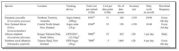
Table 5 Total cost and cost per data point of different wildlife tracking case studies [14]
As we can see in the figure above, the general cost depends not only on the technology but also in the number of animals to be track, when using GPS or Argos, the cost por animal is not reduce significantly if more animals are being tracked.
Another important point to take into account when selecting the system is the marginal cost of finding additional location points. While in GPS is effectively nil, users of the Argos system pay for the time used to calculate positions. Thus, an increase in the number of locations would increase the total cost of the project.
Nevertheless, in GPS part of this added functionality and therefore cost, is increased with the initial transmitter cost. Although GPS tracking devices do not present extra location-acquisition cost, more accurate devices result in higher initial investment.
Also, any increase in data download frequency in Argos would also increase the cost.
Finally, by looking at the table that in general terms Argos systems results being cheaper long term and the final decision of the system acquisition would be the number of animals that compose the study, the frequency of the data acquisition, position accuracy, system robustness and other characteristics directly related to each particular project.
6. Conclusion
In the proposed work, some technological characteristics and components of Argos system has been summarized. The document highlights the key method and operation mechanism of the system and its history. The evolution from its beginning until the most up-to-date system shows some technological developments performed in the ordinary system called Argos-1 to Aros-2, Argos-3 and now Argos-4. The integration and performance of Argos with the GPS is also covered as an alternative to the conventional Argos System.
Furthermore, we have explored some of the many applications of Argos system including environmental concern applications such as meteorological, wildlife preserving or others like public health protection or maritime security. Finally, the last part of the document portrays the current prices of the systems and receives finalizing with a comparison with some of the alternatives to the Argos system.
7. References
- Collecte localization satellites ( www.cls.fr )
- International governmental oceanographic (ftp.jcommops.org)
- Eoportal directory (www.directory.eoportal.org)
- Argos Comp (http://www.argoscomp.com)
- Specifications for a Multi-Standard SBCD/ARGOS-3 Integrated UHF Satellite Receiver by “Mendes”
- Argos system org, Argos Angels. (http://www.argos-system.org/argos-angels/?idpage=3506)
- Syrlinks webpage. (https://www.syrlinks.com/en/corporate/success-stories/the-first-argos-4-referenced-beacons-for-cnes-are-designed-and-manufactured-by-syrlinks)
- Eumetsat webpage. (https://www.eumetsat.int/website/home/News/DAT_3104701.html?lang=EN)
- Jamstec webpage. (https://www.jamstec.go.jp/e/about/press_release/20160129/)
- ARGOS Policy Brief on Semantic Interoperability.
(https://www.ncbi.nlm.nih.gov/pmc/articles/PMC4896070/)
- The Mentor initiative webpage.
- Argos system org, Argos Applications. (http://www.argos-system.org/applications-argos/)
- Argos system org, Wildlife brochure.
(http://www.argos-system.org/wp-content/uploads/2016/08/r238_f34_wildlife_brochure_web.pdf )
- Wildlife tracking technology options and cost considerations. Bindi Thomas, John D. Holland and Edward O. Minot. Institute of Natural Resources, Massey University, Private Bag 11-222, Palmerston North, New Zealand.
- CLS America webpage. (https://www.clsamerica.com/ )
- Argos system org, User manual.
(http://www.argos-system.org/manual/3-location/34_location_classes.htm )
- Using The ARGOS System to Transmit GPS Positions Chuck Kurnik, UNAVCO
- Argos 3, the new generation. CLS whitepaper. Publication director: Christophe Vassal.
Cite This Work
To export a reference to this article please select a referencing stye below:
Related Services
View all


Related Content
All TagsContent relating to: "Engineering"
Engineering is the application of scientific principles and mathematics to designing and building of structures, such as bridges or buildings, roads, machines etc. and includes a range of specialised fields.
Related Articles

DMCA / Removal Request
If you are the original writer of this dissertation and no longer wish to have your work published on the UKDiss.com website then please: